Earthquake plate tectonic- Geomorphology Chapter
•Download as PPT, PDF•
10 likes•4,462 views

Earthquake plate tectonic- Geomorphology Chapter

Recommended
More Related Content
What's hot
What's hot (20)
Similar to Earthquake plate tectonic- Geomorphology Chapter
Similar to Earthquake plate tectonic- Geomorphology Chapter (20)
More from Kaium Chowdhury
More from Kaium Chowdhury (20)
Recently uploaded
Recently uploaded (20)
Earthquake plate tectonic- Geomorphology Chapter
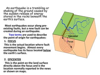
- 1. An earthquake is a trembling or shaking of the ground caused by the sudden release of energy stored in the rocks beneath the earth’s surface. Most earthquakes occur along pre- existing faults, but a new fault can be created during an earthquake. Two terms are used to describe the point of origin for earthquakes: 1. FOCUS This is the actual location where fault movement begins. Almost every earthquake has its focus located below the earth's surface. 2. EPICENTER This is the point on the land surface directly above the focus and is the location normally reported in the news or shown on maps.
- 4. • An Earthquake is a sudden tremor or movement of the earth's crust, which originates naturally at or below the surface. The word natural is important here, since it excludes shock waves caused by French nuclear tests, man made explosions and landslides caused by building work. • There are two main causes of earthquakes. • Firstly, they can be linked to explosive volcanic eruptions; they are in fact very common in areas of volcanic activity where they either proceed or accompany eruptions. • Secondly, they can be triggered by Tectonic activity associated with plate margins and faults. The majority of earthquakes world wide are of this type. • (A volcano is an opening, or rupture, in a planet's surface or crust, which allows hot magma, volcanic ash and gases to escape from below the surface)
- 5. • Most earthquakes are causally related to compressional or tensional stresses built up at the margins of the huge moving lithospheric plates that make up the earth's surface. • The immediate cause of most shallow earthquakes is the sudden release of stress along a fault, or fracture in the earth's crust, resulting in movement of the opposing blocks of rock past one another. • These movements cause vibrations to pass through and around the earth in wave form, just as ripples are generated when a pebble is dropped into water. Volcanic eruptions, rockfalls, landslides, and explosions can also cause a quake, but most of these are of only local extent. •
- 6. Stresses Stress is the FORCE acting on a body of rock. Strain is the response of a rock to stress. It generally involves a change in shape or volume of the rock. Types of stress: •Compressional (squeezing) •Tensional (stretching) •Shear (side to side shearing) Types of strain: •Elastic deformation - changes in shape of rock are reversible. Deform it, remove the stress, and it returns to its original shape (like a rubber band or a piece of elastic) •Plastic deformation - changes in shape of rock are permanent and not reversible (like folding). Rock Behavior •Brittle - the rock breaks •Ductile - the rock flows or bends (folds are produced) Once the elastic limit is surpassed, rocks will deform plastically if the rock is ductile or they will fracture (rupture) if the rock is brittle.
- 7. Reid's Elastic Rebound Theory From an examination of the displacement of the ground surface which accompanied the 1906 earthquake, Henry Fielding Reid, Professor of Geology at Johns Hopkins University, concluded that the earthquake must have involved an "elastic rebound" of previously stored elastic stress. If a stretched rubber band is broken or cut, elastic energy stored in the rubber band during the stretching will suddenly be released. Similarly, the crust of the earth can gradually store elastic stress that is released suddenly during an earthquake. This gradual accumulation and release of stress and strain is now referred to as the "elastic rebound theory" of earthquakes. Most earthquakes are the result of the sudden elastic rebound of previously stored energy.
- 8. • Earthquakes are three dimensional events, the waves move outwards from the focus, but can travel in both the horizontal and vertical plains. This produces three different types of waves which have their own distinct characteristics and can only move through certain layers within the Earth. Lets take a look at these three forms of shock waves. • Types of shockwaves • P-Waves Primary Waves (P-Waves) are identical in character to sound waves. They are high frequency, short-wavelength, longitudinal waves which can pass through both solids and liquids. The ground is forced to move forwards and backwards as it is compressed and decompressed. This produces relatively small displacements of the ground.
- 9. • L-waves move particles in a circular path. S-waves move particles at 90° to the wave's direction Particles are compressed and expanded in the wave's direction.
- 10. • S-Waves Secondary Waves (S-Waves) travel more slowly than P-Waves and arrive at any given point after the P-Waves. Like P-Waves they are high frequency, short-wavelength waves, but instead of being longitudinal they are transverse. They move in all directions away from their source, at speeds which depend upon the density of the rocks through which they are moving. They cannot move through liquids. On the surface of the Earth, S-Waves are responsible for the sideways displacement of walls and fences, leaving them 'S' shaped.
- 11. • L-Waves Surface Waves (L-Waves) are low frequency transverse vibrations with a long wavelength. They are created close to the epicentre and can only travel through the outer part of the crust. They are responsible for the majority of the building damage caused by earthquakes. This is because L Waves have a motion similar to that of waves in the sea. The ground is made to move in a circular motion, causing it to rise and fall as visible waves move across the ground. Together with secondary effects such as landslides, fires and tsunami these waves account for the loss of approximately 10,000 lives and over $100 million per year
- 13. Depth of the earthquakes The max. depth is 670 km. They are classified into three groups. 1. Shallow 0-70 km 85% 2. intermediate focus 70-350 km 12% 3. Deep focus 350-700 km 3% The shallow focus quakes are more common, because rocks are more brittle on the surface.
- 14. • EARTHQUAKE STRENGTH • The strength or size of the earthquake is measured in two ways • 1. INTENSITY SCALE • This is a measure of the damage caused by the earthquake on humans and buildings. • Intensities are pressed in roman numerals I-XII on the modified MERCALLI SCALE, where higher numbers indicate more damage. • VI. everybody feels it, they are scared run 0utdoors (damaged chimneys) • VII. Damage slight. Partial collapse in weak badly designed buildings • VIII. Damage slight in well designed building, worse in poorly designed ones. so on. • XII. damage is total. • There is a problem with using this scale, because it is only measures the amount of damage caused in human structures, and there is big difference in building designs. Underlying geology is also important. Houses built on solid rocks are much better for surviving than unconsolidated sediment.
- 15. • MAGNITUDE SCALE • The second method is to measure the Magnitude of an earthquake (RICHTER SCALE). In this method people calculate the energy released during the quake. Richter Scale Comments 2.0 Smallest earthquake detectable by people 5.0 Energy released by the Hiroshima atomic bomb. 6.0-6.9 About 120 shallow earthquakes of this magnitude occur each year 6.7 Northridge, California earthquake 1994. 7.0 Major earthquake. 7.4 Turkey earthquake August 17, 1999. More than 12,000 people killed. 7.6 Deadliest earthquake this century. Tangshan, China, 1976. About 250,000 people died. 8,3 San Francisco earthquake of 1906. 8.6 Most powerful earthquake recorded in the last 100 years. Southern Chile 1960. Claimed 5,700 lives.
- 16. • EFFECT OF EARTHQUAKES • 1.GROUND MOTION • This is the trembling and shaking of the land that can cause the buildings to vibrate. In large quakes the motion is visible. • Because proper building construction can reduce the damage in a great deal, building codes has to be very strict in special areas. Their location also has to be controlled. (hard rock!) • 2.FIRE • Particularly serious problem after an earthquake, because of the frequently broken gas and water pipes, and fallen electrical wires. (San Francisco 1906) • 3.LANDSLIDES • They can be triggered by shaking the ground (1959 Madison Canyon) 1970 Peru huge mud flows in the Andes!! • 4. PERMANENT DISPLACEMENT OF THE SURFACE • 5.AFTERSHOCKS • Small earthquakes following the big ones. Although they are smaller they still can cause damage in the weakened constructions.
- 17. • The level of damage done to a structure depends on the amplitude and the duration of shaking. The amplitudes are largest close to large earthquakes and the duration generally increases with the size of the earthquake (larger quakes shake longer because they rupture larger areas). Regional geology can affect the level and duration of shaking but more important are local site conditions. Although the process can be complicated for strong shaking, generally shaking in soft sediments is larger and longer than when compared with the shaking experienced at a "hard rock" site.
- 18. • 6. TSUNAMIS • The term tsunami comes from the Japanese 津波 , composed of the two kanji 津 (tsu) meaning "harbor" and 波 (nami), meaning "wave". The waves generated in the oceans triggered by high magnitude earthquakes in the ocean-floor s (exceeding 7.5 on Richter scale). • Seaquake; initiate huge wave.... (seismic sea waves) Hurricane can have a wavelength of 400 m, however a tsunami may have a wavelength of 100 miles and may be moving 450 miles/hour. The wave height near the shore can be 15-30 m. • Because of the long wavelength of the tsunamis it will not withdraw fast, but the water will rise for 5-10 minutes, causing flood.
- 19. • 7. LIQUEFACTION • In areas where unconsolidated sediment (Unconsolidated sediments are sediments ranging from clay to sand to gravel, with connected pore spaces that allow Groundwater to be stored and transported) is water filled, during the quake the sediment turns into liquid that is not capable to support buildings. Buildings will collapse an sewage tanks and other underground constructions will float up to the surface. Liquefaction is a phenomenon in which the strength and stiffness of a soil is reduced by earthquake shaking or other rapid loading. Liquefaction and related phenomena have been responsible for tremendous amounts of damage in historical earthquakes around the world. Liquefaction occurs in saturated soils, that is, soils in which the space between individual particles is completely filled with water. This water exerts a pressure on the soil particles that influences how tightly the particles themselves are pressed together. Prior to an earthquake, the water pressure is relatively low. However, earthquake shaking can cause the water pressure to increase to the point where the soil particles can readily move with respect to each other.
- 20. • :
- 22. • Ring of Fire (Circum-Pacific Belt: The circum-pacific belt includes the eastern and western coastal areas of the Pacific ocean ( or the western coastal margins of North and South Americas and the eastern coastal margins of Asia).
- 23. • Mid-Continental Belt: This belt includes Alpine mountain chains and the Mediterranean Sea and the fault zone of eastern Africa.
- 24. • Earthquakes and Plate Tectonics • The world's earthquakes are not randomly distributed over the Earth's surface. They tend to be concentrated in narrow zones. Why is this? And why are volcanoes and mountain ranges also found in these zones, too? • Plate tectonics tells us that the Earth's rigid outer shell (lithosphere) is broken into a mosaic of oceanic and continental plates which can slide over the plastic aesthenosphere, which is the uppermost layer of the mantle. The plates are in constant motion. Where they interact, along their margins, important geological processes take place, such as the formation of mountain belts, earthquakes, and volcanoes. • How are earthquakes connected with plate tectonics?
- 26. • Major tectonic events associated with these plate boundaries are ruptures and faults along the constructive plate boundaries, faulting and folding along the destructive plate boundaries and transform faults along the conservative plate boundaries. All sorts of disequilibrium are caused due to different types of plate motions and consequently earthquakes of varying magnitudes are caused.
- 28. • Plate tectonics confirms that there are four types of seismic zones. • Shallow and moderate earthquakes (25-35km , few 60km) are caused along constructive plate boundaries because the faults and rate of rupture of the crust and consequent movement of plates away from the mid-oceanic ridges is rather slow and the rate of upwelling of lavas due to fissure flow is also slow. Theses types follow the line of mid-ocean ridges. Activity is low, and it occurs at very shallow depths. The point is that the lithosphere is very thin and weak at these boundaries, so the strain cannot build up enough to cause large earthquakes. Associated with this type of seismicity is the volcanic activity along the axis of the ridges (for example, Iceland, Azores, Tristan da Cunha).
- 30. • The second type of earthquake associated with plate tectonics is the shallow-focus event unaccompanied by volcanic activity. The San Andreas fault is a good example of this, so is the Anatolian fault in Northern Turkey. In these faults, two mature plates are scraping by one another. The friction between the plates can be so great that very large strains can build up before they are periodically relieved by large earthquakes.
- 31. • The third type of earthquake is related to the collision of oceanic and continental plates. One plate is thrust or subducted under the other plate so that a deep ocean trench is produced. In the Philippines, ocean trenches are associated with curved volcanic island arcs on the landward plate, for example the Java trench. This type of earthquake can be shallow, intermediate, or deep, according to its location on the downgoing lithospheric slab. Such inclined planes of earthquakes are know as Benioff zones.
- 32. • Studies of fault motions from seismic waves generated in this zone indicate that the type of faulting varies with depth. Near the walls of the trench, normal faulting is typical, resulting from tensional stresses generated by the initial bending of the plate. In the zone of the shallow earthquakes, thrust faulting dominates as the descending lithosphere slides beneath the upper plate. At intermediate depths, extension or compression can occur, depending on the specific characteristics of the subduction zone. Extension and normal faulting result when a descending slab, which is denser than the surrounding mantle, sinks under its own weight. Compression results if the mantle resists the downward motion of the descending slab of lithosphere, indicating that the mantle material at the depth resists the movement of the descending plate.
- 33. 0–100 100–200 200–300 300–400 400–500 >600 Focal depthNormal faulting from tension and bending of plate Thrust faulting from plates sliding past each other Extension or compression faulting from sinking plate
- 35. • The fourth type of seismic zone occurs along the boundaries of continental plates. Typical of this is the broad swath of seismicity from Burma to the Mediterranean, crossing the Himalayas, Iran, Turkey, to Gibraltar. Within this zone, shallow earthquakes are associated with high mountain ranges where intense compression is taking place. Intermediate- and deep-focus earthquakes also occur and are known in the Himalayas and in the Caucasus.
- 38. • In summary, plate tectonics is a blunt, but, nevertheless, strong tool in earthquake prediction. It tells us where 90 percent of the Earth's major earthquakes are likely to occur. It cannot tell us much about exactly when they will occur. For that, we must study in detail the plate boundaries themselves. Perhaps the most important role of plate tectonics is that it is a guide to the use of finer techniques for earthquake prediction.
- 39. • The generation of magma at Divergent plate margins • Why and how is magma generated along spreading centers rather than in some other places? The answer lies in the special characteristics of temperature and pressure in the asthenosphere and in their relationship to the melting of minerals in the mantle. The generation of magma along divergent plate margins is not the result of high temperature alone; it is also related to the effects of pressure and temperature at which melting occurs. • The balance of temperature, pressure and composition in asthenosphere (between 100 and 200 km below the surface) allows some melting to occur. In the overlying lithosphere, the temperature is too low for melting to occur. In the underlying mantle, the confining pressure is so great that the rocks are kept well under their melting point. The balance that permits some minerals to melt is reached in the asthenosphere.
- 40. • Each mineral in a rock has its own melting point. • One factor particularly enhances the generation of magma along spreading centers. As the magma moves upward, the pressure is reduced and the decrease in pressure lowers the temperature at which melting occurs. Magma is thus generated along spreading centers, in contrast to other zones, largely because of pressure.
- 42. • The generation of magma at Convergent plate margins
- 44. • The first is a Convergent boundary, where one plate is literally going over another plate. Through a subduction zone (where one plate goes under another) this causes movement and earthquakes. Thrust faults are then created because the upper plate is being pushed into a fold or broken by thrust faults. Rock layers also scrape off the ocean floor and are then stacked into piles against the upper plate creating island and mountain chains.
- 45. • Another boundary is the Divergent boundary: this is where the plates separate and move apart. They often form a rift zone. Most are located on the oceanic floor where new seafloor is created at the separating edges. One example is the Mid- Atlantic Ridge.
- 46. • Another plate boundary is called the Strike-Slip or Transform Fault where the plates are sliding against one another without spreading apart or going over or under each other. They are also found on the ocean floor. The San Andreas fault in California .