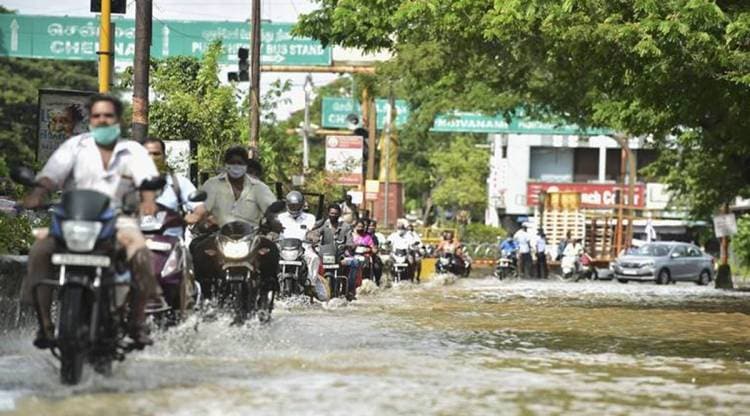
 Vehicles ply on waterlogged road of Indira Gandhi Square after heavy rain following the landfall of Cyclone Nivar, in Puducherry, Thursday, Nov. 26, 2020. (PTI Photo/R Senthil Kumar)
Cyclone Nivar, Weather Forecast Highlights: The estimated loss to agriculture and other sectors due to cyclone Nivar has been tentatively put at Rs 400 crore and a full assessment is being made, Puducherry Chief Minister V Narayanasamy said on Thursday after visiting localities affected by the cyclonic storm when it made landfall in the early hours.
Paddy crops over an extent of 820 hectares besides vegetables on 200 hectares, sugarcane on 170 hectares, 55 hectares of banana crop and betel leaf cultivated on seven hectares had been severely hit by the torrential rains, the chief minister said. Puducherry administration would seek an interim relief of Rs 50 crores from the Centre, he told reporters.
A full assessment was being made by the departments on the total quantum of loss in farm and other sectors although it had been estimated tentatively that the loss would be Rs 400 crore, Narayanasamy said.
The India Meteorological Department (IMD) has announced that the depression over south coastal Andhra Pradesh has moved north-northeastwards and weakened into a low pressure area. The low pressure area lay centered over south coastal Andhra Pradesh and westcentral Bay of Bengal at 5.30 am Friday.
The IMD has issued a yellow alert in coastal Andhra Pradesh and has forecast heavy rainfall in isolated places in Chittoor, Kurnool, Prakasam, Cuddappa and Nellore Friday.
Chennai cyclone helplines: 044 25384530 or 044 25384540 or the control room 1913 (available 24×7)
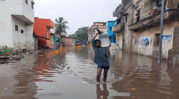 A man wades through a waterlogged street in Chennai following heavy rains ahead of Cyclone Nivar. Express Photo: Srinivas K
The Regional Meteorological Centre (RMC) in Chennai said that a low pressure area over the Bay of Bengal on November 30 could bring more rains to Tamil Nadu and Puducherry from December 1.
Deputy Director General of Meteorology, Chennai, S Balachandran, told reporters that the system was likely to intensify into a depression later. "A low pressure area is likely to form over southeast Bay of Bengal during the next 48 hours. It is very likely to intensify into a depression on November 30 and move towards the Tamil Nadu coast," he told reporters in Chennai.
As a result, there will be widespread rains in Tamil Nadu and neighbouring Puducherry from December 1-3, he said.
The forecast for more rains for the southern state and the union territory comes a day after severe cyclonic storm 'Nivar' made landfall between Tamil Nadu and Puducherry early on Thursday, bringing sharp showers.
Read more
The India Meteorological Department (IMD) has announced that the depression over south coastal Andhra Pradesh has moved north-northeastwards and weakened into a low pressure area. The low pressure area lay centered over south coastal Andhra Pradesh and westcentral Bay of Bengal at 5.30 am today.
With Chennai International Airport having resumed operations on Thursday after Cyclone Nivar made landfall near Puducherry, a total of 204 flights will be operated between Chennai and major cities today, with 102 arrivals and 102 departures scheduled at the Chennai International Airport.
Officials at the airport have also urged travellers to check with the respective airlines for any changes in schedule.
Puducherry Chief Minister V Narayanaswamy expressed relief that 'Nivar' had caused no big loss and there was no loss of life. "I thank the Almighty for saving Puducherry from the fury of the cyclone," he said appreciating the team work of all departments, the NDRF team and defence personnel.
Puducherry registered 27 cm rainfall while Karaikal recorded 10 cm in the 24 hours ending 8.30 am Thursday. Water was drained from low lying areas and various housing colonies using pumps. All trees that were uprooted under the strong winds were being removed, the chief minister said.
The India Meteorological Department (IMD) has announced that a low pressure area is very likely to form over southeast Bay of Bengal over the next 48 hours. According to S Balachandran, the director of the Regional Meteorological Centre (RMC) in Chennai, said that it is very likely to intensify into a depression during the subsequent 24 hours around November 30 and move towards the Tamil Nadu coast.
The IMD has forecast enhanced rainfall activity over Tamil Nadu and Puducherry from December 1 to December 3.
The estimated loss to agriculture and other sectors due to cyclone Nivar has been tentatively put at Rs 400 crore and a full assessment is being made, Puducherry Chief Minister V Narayanasamy said on Thursday after visiting localities affected by the cyclonic storm when it made landfall in the early hours.
Paddy crops over an extent of 820 hectares besides vegetables on 200 hectares, sugarcane on 170 hectares, 55 hectares of banana crop and betel leaf cultivated on seven hectares had been severely hit by the torrential rains, the chief minister said. Puducherry administration would seek an interim relief of Rs 50 crores from the Centre, he told reporters.
A full assessment was being made by the departments on the total quantum of loss in farm and other sectors although it had been estimated tentatively that the loss would be Rs 400 crore, Narayanasamy said.
Slammed by the severe cyclonic storm Nivar early Thursday, Tamil Nadu is likely to receive another spell of very heavy rainfall as a fresh low pressure area is expected to form in the Bay of Bengal from November 29 onwards, the IMD said.
India Meteorological Department (IMD) Director General Mrutunjay Mohapatra said the low pressure area likely to form on November 29 may bring very heavy rains over Tamil Nadu.
He, however, said it needs to be seen whether the low pressure area will intensify into a cyclone. A low pressure area is the first stage of formation of a cyclone. "We are closely monitoring it (the low pressure area)," Mohapatra said.
Read more
Heavy rainfall lashed eastern and southeastern Bengaluru on Thursday and most of the other areas received light to moderate showers due the impact of cyclone Nivar. The rain has brought down the temperature in the city
According to KSNDMC, Bommanahalli and Mahadevapura zones received more than 29 mm of rainfall. RR Nagar and Dasarahalli zones received 5-10 mm of rain.
Varthur received 29 mm of rain Begur, Indiranagar, HSR Layout, Marathahalli, Bellandur, Indiranagar, Doddanekkundi and Yelahanka received between 18 mm to 25 mm of rainfall. Banashankari, Yelahanka, parts of Basavanagudi, Jayanagar and Mysuru Road received light showers.
The India Meteorological Department had sounded a yellow alert in Bengaluru Urban and Rural, Kolar, Chikkaballapur, Tumakuru, Mandya, and Ramanagara districts of Karnataka on November 26. "These districts are very likely to experience isolated heavy rainfall on November 26," C S Patil, IMD Bengaluru Director said.
South Interior Karnataka was expected to experience rainfall on November 26 and light to moderate scattered rainfall on November 27. North Interior Karnataka is very likely to experience isolated rainfall on 27 and 28 Nov, IMD said. Coastal Karnataka will experience isolated rainfall on November 27 and 28. “Bengaluru is very likely to experience rain on November 26 and 27,” Patil added.
The Southern Railway has announced that workmen special train services in Chennai, which had been suspended due to Cyclone Nivar will resume operations from Friday.
The IMD has issued a yellow alert in coastal Andhra Pradesh and has forecast heavy rainfall in isolated places in Chittoor, Kurnool, Prakasam, Cuddappa and Nellore today.
Cyclone Nivar has weakened from a deep depression into a depression over south coastal Andhra Pradesh. According to the India Meteorological Department (IMD), the deep depression over south Rayalseema had moved north-northwards with a speed of 8 kmph before weakening into a depression.
The depression lay centered over south coastal Andhra Pradesh near latitude 14°N and longitude 79.5°E, about 35 km north of Tirupati and 70 km south-southwest of Nellore at 11.30 pm on November 26. The depression is expected to move northwards and weaken into a low pressure area over the next 12 hours.
People stand in a queue to board the metro train during rain after the landfall of Cyclone Nivar, in Bengaluru, Thursday, Nov. 26, 2020. (PTI Photo)
An aerial view of flooded Mudichur area following heavy rain triggered by Cyclone Nivar, in Chennai, Thursday, November 26, 2020. (PTI Photo)
NDRF personnel carry out a rescue operation to move locals to safer places after the landfall of Cyclone Nivar, at Mudichur in Chennai, Thursday, Nov. 26, 2020. (PTI Photo)
The cyclonic storm Nivar weakened into a deep depression and lay centered over south Rayalaseema and neighbourhood, about 30 km west-southwest of Tirupathi and 115 km west-northwest of Chennai, the India Meteorological Department (IMD) said in a bulletin at 5.30 pm. The cyclone was moving at 13 kmph during the past six hours and is very likely to move nearly northwards, weaken into a depression during the next six hours and into a low pressure area during the subsequent 12 hours.
Slammed by the severe cyclonic storm Nivar early Thursday, Tamil Nadu is likely to receive another spell of very heavy rainfall as a fresh low pressure area is expected to form in the Bay of Bengal from November 29 onwards, the IMD said.
India Meteorological Department (IMD) Director General Mrutunjay Mohapatra said the low pressure area likely to form on November 29 may bring very heavy rains over Tamil Nadu.
He, however, said it needs to be seen whether the low pressure area will intensify into a cyclone. A low pressure area is the first stage of formation of a cyclone. "We are closely monitoring it (the low pressure area)," Mohapatra said. (PTI)
Storm-affected people take refuge at a relief camp, in the aftermath of cyclone Nivar yesterday night, in Puducherry, Thursday, November 26, 2020. (PTI Photo)
The cyclonic storm Nivar weakened into deep depression and lay centred at over south Rayalaseema and neighbourhood, about 50 km west-southwest of Tirupathi and 115 km west-northwest of Chennai. The deep depression is very likely to move nearly northwards, weaken further into a depression during next six hours and into a low pressure area by subsequent 12 hours.
The Southern Railway has announced that workmen special train services in Chennai, which had been suspended due to Cyclone Nivar will resume operations from Friday.
Vehicles ply on waterlogged road of Indira Gandhi Square after heavy rain following the landfall of Cyclone Nivar, in Puducherry, Thursday, November 26, 2020. (PTI Photo)
The Southern Railway has announced that special trains between Tamil Nadu and Mangalore and Tamil Nadu and Alappuzha, which had been cancelled owing to Cyclone Nivar will run as scheduled today.
The Regional Meteorological Centre (RMC) in Chennai has forecast that a low pressure area will likely be formed over south Bay of Bengal around November 29. This is expected to become more marked and move in a westwardly direction towards south Tamil Nadu.
Met Dept forecasts thunderstorms with lighting (with wind speed reaching 41 to 61 kmph) in Bengaluru Urban, Bengaluru Rural, Tumkur, Kolar, Chikkaballapura, Ramanagara, and Mandya this evening.
With Cyclone Nivar 60 km north of Puducherry and no loss of life and major damages reported in the union territory, the Puducherry government has revoked prohibitory orders issued under Section 144 in Puducherry.
The India Meteorological Department has forecast thunderstorm with lighting in Bengaluru Urban, Bengaluru Rural, Tumkur, Kolar, Chikkaballapura, Ramanagara, and Mandya districts later this evening.
As per a forecast issued at 4 pm, "Thunderstorm with lightning, with wind speed reaching 41 to 61 kmph accompanied with moderate spells of rain" is likely to affect these districts in the next three hours.
Hitting out the ruling AIADMK government amid rescue and relief operations in Tamil Nadu after Cylone Nivar made landfall near Puducherry on Wednesday, DMK leader MK Stalin said that even after the December 2015 floods in Chennai, the government seems to have not learnt a lesson from disasters.
"The CAG report was never found and the court order was not complied with. The AIADMK government should provide a compensation of Rs. 5000 to affected parties in the state for its lack of action", he alleged.
The Southern Railway resumed suburban train services in Chennai today. Train services had been halted at 10 am on Wednesday owing to heavy rainfall in the city ahead of Cyclone Nivar's landfall.
The suburban trains will be operated from 3 pm to 8 pm today. One EMU special train will be operated every one hour from each end along the following routes:
The India Meteorological Department has sounded a yellow alert in Bengaluru Urban and Rural, Kolar, Chikkaballapur, Tumakuru, Mandya, and Ramanagara districts of Karnataka on November 26. "These districts are very likely to experience isolated heavy rainfall on November 26," C S Patil, IMD Bengaluru Director said.
South Interior Karnataka is very likely to experience rainfall on 26 Nov and light to moderate scattered rainfall on November 27. North Interior Karnataka is very likely to experience isolated rainfall on November 27 and 28, IMD said.
Coastal Karnataka to experience isolated rainfall on November 27 and 28. “Bengaluru is very likely to experience rain on November 26 and 27,” Patil added.
NDRF personnel rescued senior citizens in cyclone-affected areas of Tamil Nadu and Puducherry.
Airport operations resumed in Chennai Thursday after very severe cyclonic storm Nivar made landfall near Puducherry, authorities said.
"Operations have resumed at #AAI #ChennaiAirport at 0900hrs," the Chennai Airport tweeted and it also tagged domestic arrival and departure schedule for today and requested passengers to check with airline operators for updates.
The Greater Chennai Corporation (GCC) has cleared a total of 223 trees out of the 267 trees that had been felled in the city following heavy rainfall on Wednesday.
The GCC cleared six trees each in Madhavaram (Zone 3), Ambattur (Zone 7), Alandur (Zone 12) and Sholinganallur (Zone 15); nine in Tondiarpet (Zone 4), 29 each in Royapuram (Zone 5) and Anna Nagar (Zone 8); 12 in Thiru.Vi.Ka Nagar (Zone 6), 22 in Teynampet (Zone 9), 45 in Kodambakkam (Zone 10), one in Valasaravakkam (Zone 11), 48 in Adyar (Zone 13) and four in Perungudi (Zone 14).
The Greater Chennai Corporation (GCC) has cleared a total of 288 lamp posts in Chennai that had fallen down in Chennai following heavy rainfall in the city.
The GCC cleared five lamp posts each in Tiruvottiyur (Zone 1) and Manali (Zone 2); six in Madhavaram (Zone 3), 15 in Tondiarpet (Zone 4), 13 in Royapuram (Zone 5), 19 in Thiru.Vi.Ka Nagar (Zone 6), 123 in Ambattur (Zone 7), 28 in Anna Nagar (Zone 8), 20 each in Teynampet (Zone 9) and Kodambakkam (Zone 10); one in Valasaravakkam (Zone 11), three in Alandur (Zone 12), 11 in Adyar (Zone 13), seven in Perungudi (Zone 14) and 12 in Sholinganallur (Zone 15).
Chennai Metro Rail Limited (CMRL) commenced metro services in Chennai at 12 pm today in the wake of Cycline Nivar. The trains will be operated following the holiday services time table with a headway of 10 minutes.
A falling tree killed a 50-year-old man in Chennai's Besant Nagar today. The man was rushed to a hospital in Royapettah where doctors declared him dead on arrival.
The India Meteorological Department (IMD) has issued an orange alert in coastal and north interior Tamil Nadu, Puducherry and Telangana as parts of the two states and union territory are set to heavy rainfall today.
The India Meteorological Department (IMD) has issued a red alert in coastal Andhra Pradesh and Rayalseema. According to the IMD, parts of Chittoor, Kurnool, Prakasam, Cuddappa and Rayalseema will receive heavy to very heavy rainfall today.
Tamil Nadu Chief Minister Edappadi K Palaniswami commended the work being by R S Rajesh, the North (East) District Secretary for North Chennai in the removal of trees which had been felled following heavy rains in Chennai as Cyclone Nivar made landfall near Puducherry on Wednesday night.
In a video shared by EPS on Twitter, Rajesh can be seen aiding Greater Chennai Corporation (GCC) workers in removing trees that had fallen across the road.
The Indian Meteorological Department (IMD) has announced that the severe cyclonic storm Nivar over north coastal Tamil Nadu has moved northwestwards with a speed of 13 kmph over the past six hours. Cyclone NIVAR, which has weakened into a cyclonic storm lay centered over north coastal Tamil Nadu near latitude 12.6°N and longitude 79.4°E, about 85 km north-northwest of Puducherry and about 95 km west-southwest of Chennai at 8.30 am on Thursday.
The IMD said that the cyclonic storm will continue to move northwestwards and weaken further into a deep depression over the next six hours, before weakening into a depression over the subsequent six hours.
Conservancy workers and officials from the Greater Chennai Corporation (GCC) have been working round the clock to clear fallen trees and branches across Chennai in the wake of Cyclone Nivar.
Chennai recorded 1497.60 mm of rainfall till 6 am as the city received heavy to very heavy showers in the wake of Cyclone Nivar. The average rainfall recorded was 136.15 mm.
Here is the breakup of rainfall recorded across Chennai till 6 am:
A total of three people were reported dead in Tamil Nadu following the cross over of Cyclone Nivar near Puducherry on Wednesday night.
As per updated meteorological data, Puducherry received the highest rainfall of 30 cm, followed by Cuddalore in Tamil Nadu with 27 cm. Nagapattinam recorded 6.3 cm rainfall, Karaikal 9.6 cm and Chennai 11.3 cm.
Union Home Minister Amit Shah said that the Centre is closely monitoring the situation in Tamil Nadu and Puducherry in the wake of Cyclone Nivar which made landfall near Puducherry last night. Shah said that the Centre has assured all help from the Centre.
Tamil Nadu Electricity Minister P Thangamani said that power will be restored in localities in Chennai gradually when stagnant water has been drained. Currently, 390 localities in the cities have been waterlogged following heavy rainfall overnight as Cyclone Nivar made landfall.
Karnataka Chief Minister B S Yediyurappa on Wednesday said that the state government has taken measures to control the effect of Cyclone Nivar. “I have directed concerned officials to take necessary measures to control the effects of Cyclone Nivar in the state,” Yediyurappa said.
Owing to Cyclone Nivar, the Southern Railway has fully cancelled 69 train services to and from Tamil Nadu. Further, 21 trains have been partially cancelled while eight trains have been diverted.
The India Met Department has forecast the track and intensity of Cyclone Nirav. The weather department has predicted the storm will weaken into a deep depression by 5.30 pm, a depression by 11.30 pm and a low pressure area by 5.30 am on Friday.
A British Airways flight from Heathrow Airport was the first flight to land in Chennai, after the Chennai International Airport resumed operations at 9 am today in the aftermath of Cyclone Nivar.
The India Meteorological Department (IMD) has sounded a yellow alert in Bengaluru Urban and Rural, Kolar, Chikkaballapur, Tumakuru, Mandya, and Ramanagara districts of Karnataka on Wednesday. "These districts are very likely to experience isolated heavy rainfall on November 26 and 27," C S Patil, IMD Bengaluru Director said.
South Interior Karnataka is very likely to experience isolated rainfall on November 25, 28 and 29 and light to moderate scattered rainfall on November 26 and 27. North Interior Karnataka is very likely to experience dry weather on November 25 and 29, isolated rainfall on November 26 and 28, IMD said.
Coastal Karnataka will experience light to moderate scattered rainfall on November 27. “Bengaluru is very likely to experience rain on November 25 and 26,” Patil added.
Cyclone Nivar has weakened into a 'severe cyclonic storm', but left a trail of destruction in the form of uprooted trees and building collapses in Tamil Nadu. According to a report in PTI, at least 150 trees have been uprooted in the state alone. Several buildings have reportedly collapsed as well. However, there are no reports of loss of lives. Authorities are on their toes to clean up after the storm.
Officials at the Chennai International Airport have resumed flights services to and from the city. Operations at Chennai airport had been suspended from 7 pm on Wednesday to 9 am today owing to adverse weather conditions in Chennai.
The National Testing Agency (NTA) has postponed the CSIR UGC NET exam in Tamil Nadu and Puducherry because of the Nivar cyclone. The exam was on November 26 for mathematical science and chemical science papers. The new exam dates are yet to be announced.
"Owing to the cyclone 'Nivar' - the Joint CSIR-UGC NET 2020 exam scheduled on November 26 stands postponed until further notice in respect of all exam centres which are located in the union territory of Puducherry and state of Tamil Nadu", the NTA said in an official notice.
Read more
There is total suspension of fishing activity in Tamil Nadu and Puducherry for the next 12 hours. The weather department has warned that movement in motor boats and small ships is unsafe. It has advised fishermen not to venture into the southwest and adjoining westcentral Bay of Bengal during the next 12 hours.
Officials at the Chennai International Airport have announced that flight operations will continue to remain suspended till 9 am today, keeping in mind the safety of the traveller amid the prevailing weather.
The India Met Department has predicted heavy rainfall at isolated places in coastal and north interior Tamil Nadu today. "Rainfall at many places with heavy rainfall at isolated places," it said in its 7.50 am bulletin. Meanwhile, parts of Andhra Pradesh and Telangana will receive very heavy and extremely heavy rainfall today. South Interior Karnataka will receive rainfall at many places with heavy rainfall at isolated places.
The Tamil Nadu government has declared a public holiday in 16 districts today, namely Chennai, Kancheepuram, Chengalpet, Tiruvallur, Villupuram, Cuddalore, Tiruvannamalai, Ariyalur, Perambalur, Thanjavur, Tiruvarur, Nagapattinam, Kallakurichi, Tirupattur, Vellore and Ranipet.
The latest bulletin by IMD at 6.45 am states the cyclone lays centered over north coastal Tamil Nadu, about 50 km north-northwest of Puducherry. It is at Lat 12*4N and Long 79.6*E.