Pakistan
Federal parliamentary republic
Official:
Islamic Republic of Pakistan
Local name:
Pakistan
Region:
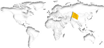
South Asia
Surface area:
796,100 km²
Capital:
Islamabad
Geography
Pakistan is a country between the Himalayas and the Arabian Gulf. The land has a total area of 796,100 km² (307,376 mi²) and a total coastline of 1,046 km (650.0 mi). This land area is approximately 114% of the area of Texas. Pakistan is thus one of the largest countries in Asia and the 35th biggest in the world. Most of the population (62%) resides within rural regions.Pakistan is comparatively high at an average elevation of 900 meters above sea level. The highest mountain peak (K2) is at 8,611 meters. The country has about 100 islands. There are direct national borders with the four neighboring countries Afghanistan, China, India and Iran. The distance between New York City and the Capital Islamabad is about 11,090 km (6,891 mi).
On further pages:
Current time in Pakistan:
The countrywide time in Pakistan is Pakistan Standard Time (PKT), which is currently 9 hours ahead of New York.
As in many countries, there is no daylight savings time in Pakistan.
Related to Greenwich Mean Time, there's the same difference of 5 hours all over the year.
Sunrise + Sunset00:00
April 2024
The countrywide time in Pakistan is Pakistan Standard Time (PKT), which is currently 9 hours ahead of New York.
As in many countries, there is no daylight savings time in Pakistan.
Related to Greenwich Mean Time, there's the same difference of 5 hours all over the year.
Population
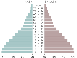
Population:235,825,000
Population per km²:296.2
Life expectancy males:Ø 63.8 years
Life expectancy females:
Ø 68.6 yearsBirth rate:
27.5 ‰Death rate:
7.2 ‰Males/Females:
50.4% : 49.6%Population pyramid
The currency in Pakistan is the Pakistanian rupee (PKR).
1 Rupee is divided into 100 Paisa.
Status: 04/30/2024
1 Rupee is divided into 100 Paisa.
Status: 04/30/2024
1 US dollar = 277.51 Rupees
1000 Rupees = 3.60 US dollar
1000 Rupees = 3.60 US dollar
Climate in Pakistan
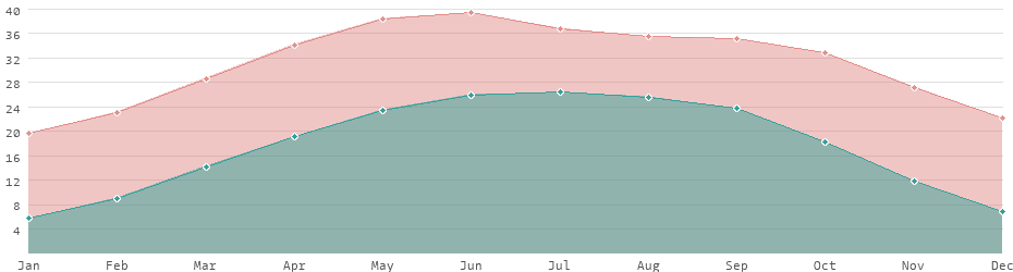
Pakistan has a subtropical climate and in most parts of the country temperatures vary between 20 and 39 degrees Celsius, depending on the season. However, in some regions, especially in the south and west of the country, temperatures can rise to as high as 42 °C during the hot summer months.The northern mountainous regions of the Hindu Kush, Himalayas and Karakoram have a temperate climate with cool summers and cold winters, often accompanied by heavy snowfall at higher altitudes. In contrast, the south including Punjab, Sindh and Baluchistan, has a more arid and desert-like climate with hot and dry summers. The monsoon season usually takes place between June and September and sometimes brings torrential rains.
Average daytime and nighttime temperatures
Languages
Official languages:
English, Urdu
| Mother tongue | Distribution |
|---|---|
| Punjabi | 48.0 % |
| English | 46.0 % |
| Pashto | 13.1 % |
| Sindhi | 11.8 % |
| Saraiki | 9.8 % |
| Urdu | 7.6 % |
| Balochi | 3.0 % |
| Hindko | 2.4 % |
| Brahui | 1.2 % |
| Gujarati | 1.2 % |
Many Pakistanis are growing up bilingual, with English becoming increasingly prevalent.
Religions
State religion:
Sunni Islam
| Religion | Distribution |
|---|---|
| Christs | 1.6% |
| Hinduists | 2.0% |
| Sunni | 80.0% |
| Shia | 15.0% |
| other | 1.4% |
more...
Economy
| GDP: | 374.70 bn $ |
| Exportations: | 38.97 bn $ |
| Importations: | 76.43 bn $ |
| › Tourism receipts: | 884.00 M $ |
| › Debt rate: | 75.75 % |
| › Unemployment rate: | 6.42 % |
| › Inflation rate: | 19.87 % |
| › Corruption index: | 29 (very bad) |
| › Energy consumption: | 103.5 bn kWh |
According to the definition from the International Monetary Fund (IMF), Pakistan is a developing country because of its lower economic performance.
With an average annual income of 1,560 USD Pakistan is one of the lower middle-income countries.
Pakistan is considered one of the most dangerous countries worldwide.
Land use
| 5% Urban areas: | 35,872 km² |
| 47% Agricultural areas: | 374,406 km² |
| 5% Forest: | 38,452 km² |
| 3% Water areas: | 25,220 km² |
| 44% Others: | 347,371 km² |
more...
Transport
| Roadways: | 263,775 km |
| Railways: | 11,881 km |
| Reg. vehicles: | 6,628,063 |
| › Airports: |
Most important cities
Population refers to the city proper, not metropolitan areas.
| City | Region | Population |
|---|---|---|
| Islamabad / Capital | Islamabad | 1,009,000 |
| Karachi | Sindh | 14,884,000 |
| Lahore | Punjab | 13,004,000 |
| Faisalabad | Punjab | 3,210,000 |
| Gujranwala | Punjab | 2,165,000 |
| Kashmor | Sindh | 2,098,000 |
| Rawalpindi | Punjab | 2,098,000 |
| Peshawar | Khyber Pakhtunkhwa | 1,970,000 |
| Multan | Punjab | 1,873,000 |
| Hyderabad | Sindh | 1,755,000 |
| Quetta | Balochistan | 999,000 |
| Kotli | Azad Kashmir | 640,000 |
| Sukkur | Sindh | 500,000 |
| Larkana | Sindh | 488,000 |
| Mardan | Khyber Pakhtunkhwa | 359,000 |
| Bhimbar | Azad Kashmir | 343,000 |
| Mingora | Khyber Pakhtunkhwa | 280,000 |
| Muzaffarabad | Azad Kashmir | 150,000 |
| Gilgit | Gilgit-Baltistan | 10,000 |
The difference between the urban area and the city proper alone can be considerable. Dera Ghazi Khan, for example, has an urban population of 534,000. However, the actual proper city is much smaller with only 218,000 inhabitants. The difference to metropolitan regions, i.e. conurbations with several cities, is even greater.
Political indicators
(Based on the "Worldwide Governance Indicators" project of the World Bank)
| Political stability: | ◈ |
| Rule of law: | ◈ |
| Effectivity: | ◈ |
| Regulatory quality: | ◈ |
| Voice accountability: | ◈ |
| Autocracy Index: | ◈ |
| Death penalty: | Legally allowed |
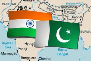 Country comparison: India / Pakistan
 India: country data and statistics
 List of 152 developing countries