Central African Republic
Presidential republic
Local name:
Centrafrique / Bê-Afrîka
Region:
Central Africa
Surface area:
622,980 km²
Capital:
Bangui
Geography
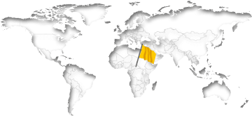
The Central African Republic is a landlocked country almost exactly in the middle of Africa a few hundred kilometers north of the equator. The land has a total area of 622,980 km² (240,534 mi²). This land area is approximately 90% of the area of Texas. Central Africa is thus the 20th biggest country in Africa and in terms of area ranked 44th worldwide. With 9.0 inhabitants per km² it is one of the most sparsely populated countries on earth. Only slightly less than half of all residents (43%) live within cities.The Central African Republic lies at an average elevation of 635 meters above sea level. The highest mountain peak (Ngaoui) is at 1,420 meters. There is no access to the open sea. There are direct national borders with the six neighboring countries Cameroon, Chad, Congo (Dem. Republic), Congo, South Sudan and Sudan. The distance between New York City and the Capital Bangui is about 9,910 km (6,158 mi).
On further pages:
Current time in the Central African Republic:
The countrywide time in the Central African Republic is West Africa Time (WAT), which is currently 5 hours ahead of New York.
As in many countries, there is no daylight savings time in the Central African Republic.
Related to Greenwich Mean Time, there's the same difference of 1 hours all over the year.
Sunrise + Sunset00:00
April 2024
The countrywide time in the Central African Republic is West Africa Time (WAT), which is currently 5 hours ahead of New York.
As in many countries, there is no daylight savings time in the Central African Republic.
Related to Greenwich Mean Time, there's the same difference of 1 hours all over the year.
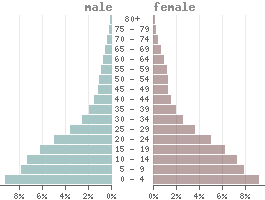
Population
Population:5,579,000
Population per km²:8.956
Life expectancy males:Ø 51.6 years
Life expectancy females:
Ø 56.3 yearsBirth rate:
42.7 ‰Death rate:
11.4 ‰Males/Females:
50.0% : 50.0%Population pyramid
The currency in the Central African Republic is the cfa-franc beac (XAF).
1 Cfa-franc beac is divided into 100 Centimes.
Status: 04/26/2024
1 Cfa-franc beac is divided into 100 Centimes.
Status: 04/26/2024
1 US dollar = 609.93 Cfa-franc beacs
1000 Cfa-franc beacs = 1.64 US dollar
1000 Cfa-franc beacs = 1.64 US dollar
Climate in the Central African Republic
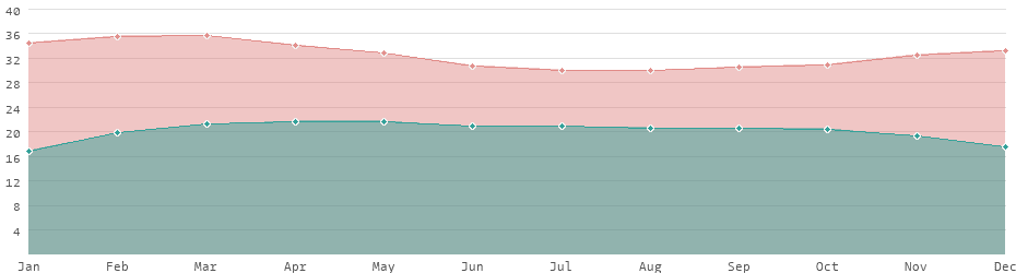
In the Central African Republic, as in all equatorial countries, there is a tropical climate. Unlike in Europe or the USA, there is almost no difference between the seasons. The daylight hours vary little, and the temperature differences between summer and winter are also lower. Depending on the season, the average daytime temperatures range between 30 and 36 degrees. In some parts of the country, the temperature rises to 40 °C. In the colder months, and depending in the region, the temperature drops to 17 °C in a month's average.Average daytime and nighttime temperatures
Languages
Official languages:
French, Sango
| Mother tongue | Distribution |
|---|---|
| Gbaya | 23.8 % |
| Banda | 23.5 % |
| Mandjia | 14.8 % |
| Ngbaka | 7.5 % |
| French | 7.5 % |
| Sango | 7.3 % |
| Mbum | 6.4 % |
| Sara | 6.4 % |
| other | 2.8 % |
Religions
| Religion | Distribution |
|---|---|
| Roman Catholics | 25.0% |
| Protestants | 25.0% |
| Native religions | 35.0% |
| Muslims | 15.0% |
Economy
| GDP: | 2.38 bn $ |
| › Tourism receipts: | 30.90 M $ |
| Debt rate: | 50.69 % |
| › Unemployment rate: | 6.36 % |
| › Inflation rate: | 5.58 % |
| › Corruption index: | 24 (very bad) |
| › Energy consumption: | 140.4 M kWh |
Due to its political and financial situation, the Central African Republic is considered one of the least developed countries in the world and is also one of the heavily indebted poor countries.
With an average annual income of 480 USD it is one of the low-income countries. Even taking purchasing power parity into account, Central Africa is still one of the poorest countries in the world.
Central Africa is considered one of the most dangerous countries worldwide.
Land use
| 8% Agricultural areas: | 50,773 km² |
| 36% Forest: | 223,027 km² |
| 56% Others: | 349,180 km² |
Transport
| Roadways: | 24,000 km |
| Waterways: | 2,800 km |
| Reg. vehicles: | 19,300 |
| › Airports: |
Most important cities
Population refers to the city proper, not metropolitan areas.
| City | Region | Population |
|---|---|---|
| Bangui / Capital | Bangui | 812,000 |
| Bimbo | Ombella-Mpoko | 268,000 |
| Mbaïki | Lobaye | 67,000 |
| Berbérati | Mambéré-Kadéï | 62,000 |
| Kaga Bandoro | Nana-Grébizi | 57,000 |
| Bozoum | Ouham-Pendé | 40,000 |
| Carnot | Mambéré-Kadéï | 38,000 |
| Sibut | Kémo | 34,000 |
| Bambari | Ouaka | 33,000 |
| Bria | Haute-Kotto | 29,000 |
| Bouar | Nana-Mambéré | 29,000 |
| Bossangoa | Ouham | 27,000 |
| Nola | Sangha-Mbaéré | 27,000 |
| Bangassou | Mbomou | 24,000 |
| Damara | Ombella-Mpoko | 20,000 |
| Mobaye | Basse-Kotto | 19,000 |
| Paoua | Ouham-Pendé | 18,000 |
| Boda | Lobaye | 17,000 |
| Ippy | Ouaka | 17,000 |
| Batangafo | Ouham | 15,000 |
| Alindao | Basse-Kotto | 14,000 |
| Zemio | Haut-Mbomou | 14,000 |
| Kabo | Ouham | 14,000 |
| Rafaï | 13,000 | |
| Bouca | Ouham | 13,000 |
| Obo | Haut-Mbomou | 13,000 |
| Ndélé | Bamingui-Bangoran | 12,000 |
| Kembé | Basse-Kotto | 12,000 |
| Birao | Vakaga | 10,000 |
Political indicators
(Based on the "Worldwide Governance Indicators" project of the World Bank)
| Political stability: | ◈ |
| Rule of law: | ◈ |
| Effectivity: | ◈ |
| Regulatory quality: | ◈ |
| Voice accountability: | ◈ |
| Autocracy Index: | ◈ |
| Death penalty: | abolished in 2022 |
Existing trade agreements
- CEMAC - Economic and Monetary Community of Central Africa
- COMESSA - Community of Sahel-Saharan States
 Country comparison: Central Africa / United States
 Cameroon: country data and statistics
 List of the 36 Heavily Indebted Poor Countries