A "radically different" flat map of the Earth has been produced by scientists who say it is more accurate than any previous 2D models that came before.
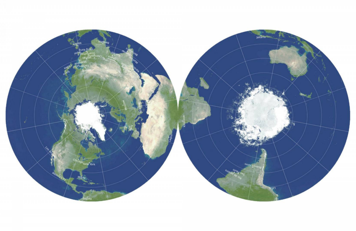
The two-sided map is made up of two circles depicting the northern and southern hemispheres stitched together side-by-side. The polar regions are at the center of each circle and the equator is at the outer edge.
It was created by scientists working at the University of Princeton and Drexel University of Philadelphia. The team wanted to resolve the persistent issue of how 2D images of the 3D globe always end up distorting the planet in some way.
"We're proposing a radically different kind of map," J. Richard Gott, a professor of astrophysical sciences at Princeton University, said in a statement.
Gott was joined by Princeton mathematician Robert Vanderbrei and physicist David Goldberg from Drexel University in Philadelphia to create the map. The group published their efforts on the pre-print open access repository arXiv.
"We believe it is the most accurate flat map of Earth yet," they wrote in the study.
The new map is the latest example of years of research and critique by Gott and his colleagues on existing 2D maps of Earth.
In 2007 Gott and Goldberg created a ranking system that gave every 2D map of the Earth a score for its accuracy based on how much it distorted key elements like distances and area. The lower the score, the better the map, with a score of 0 being perfect.
The well-known Mercator projection, which created a square map of the world by stretching the polar regions, received a score of 8.296 on their scale.
The Winkel Tripel projection used an oblong shape with less distortions than the Mercator map. However it exaggerated Antarctica and the distances between East Asia and North America, giving it a score of 4.563.
American architect and inventor Buckminster Fuller's 'dymaxion' world map used a polyhedral net intended to be built as a 3D globe. In its 2D form the map divided up the continents far away from each other. It scored over 15 on the Goldberg-Gott scale.
By using two circles instead of a stretched, single image, Gott, Goldberg and Vanderbrei were able to avoid many of these distortions and produce a more accurate flat map of the Earth. On their own scale the new map scored a record-breaking 0.881. One suggested use was to stick the two sides together like a vinyl record to create a single, double-sided circle.
3D globes of Earth, such as the end result of Fuller's dymaxion map, are closer to the reality of how our near-spherical planet actually is. However they present ergonomic and production issues because they are harder to make, store and handle.
The new model overcomes this difficulty too and is arguably even easier to handle than globes. "This is a map you can hold in your hand," Gott said. "Our map is actually more like the globe than other flat maps ... To see all of the globe, you have to rotate it; to see all of our new map, you simply have to flip it over."
Uncommon Knowledge
Newsweek is committed to challenging conventional wisdom and finding connections in the search for common ground.
Newsweek is committed to challenging conventional wisdom and finding connections in the search for common ground.
About the writer
To read how Newsweek uses AI as a newsroom tool, Click here.