A tsunami could wipe this Norwegian town off the map. Why isn’t everyone leaving?
Within decades or even months, a 300-foot wave could swallow this idyllic village. Here’s how they’re preparing

Growing up on his family fjord farm on an unimaginably steep Norwegian mountainside, Magne Åkernes learned to live with risk at every turn—especially around a crack hidden in the rockface.
“When I was little, we used to break the peat moss growing over a crack so people and animals wouldn’t fall in,” Åkernes, now 90, tells me through a translator in his living room in Norway. “We took stones and dropped them in to listen for how far they fell.”
In 1958 his family was the last to vacate the famous abandoned fjord farms in Norway’s Sunnmøre district along Sunnylvsfjorden and Geirangerfjord. He returned on a hunting trip years later to a shocking discovery: the crack, once small enough to skip over, had grown. Åkernes, named after the same mountain now splitting down the front, stretches his arms wide and his eyes get big. His family notified the authorities, who eventually realized what they were up against.
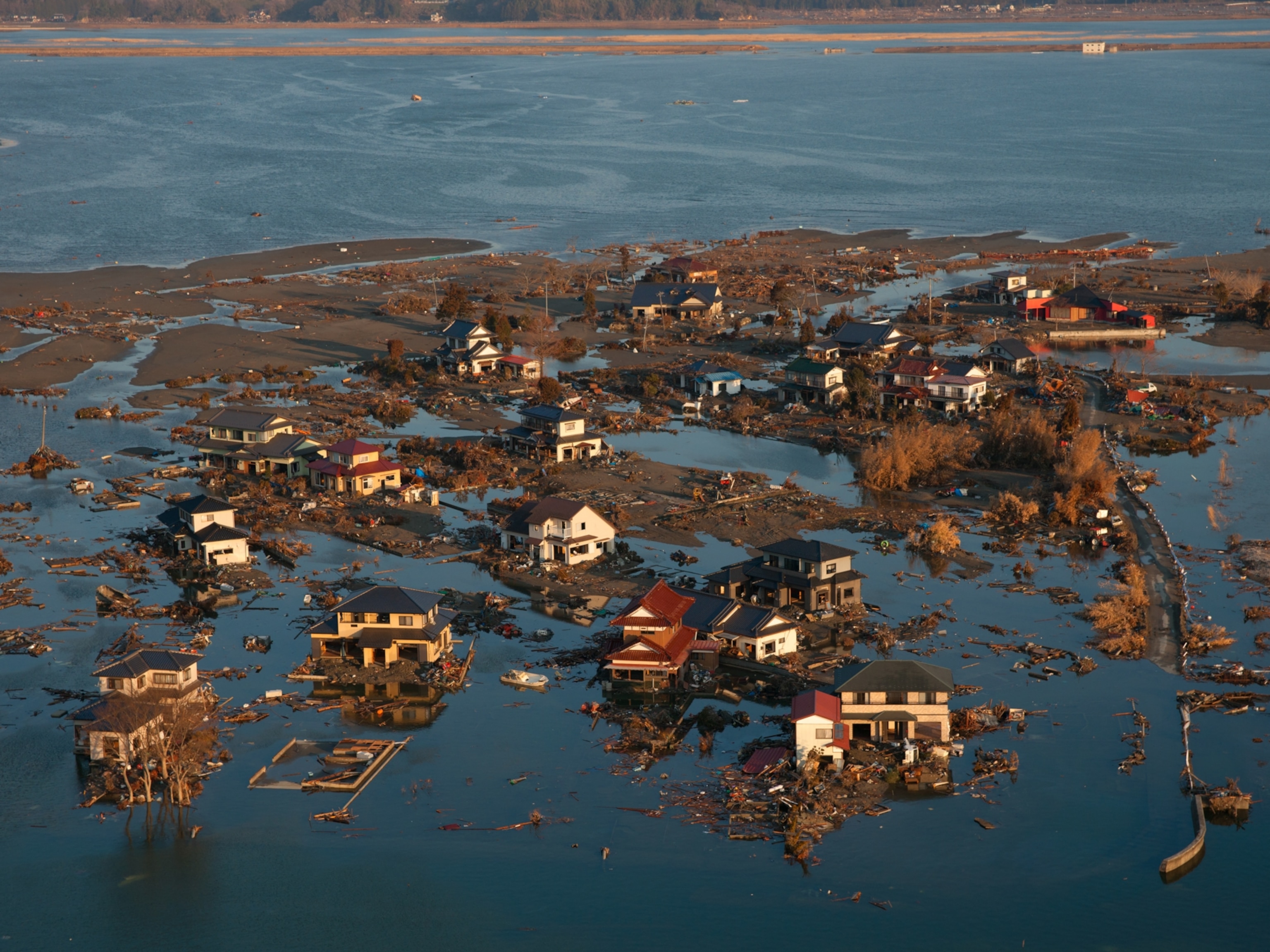
Today, reaching 230-feet deep, the Åkernes crack is growing by as much as three and a half inches a year. It is one of the most hazardous rock fractures in the world. Like nearby cliffs before, part of the mountain will eventually slide into one of Norway’s deepest fjords. But this rockslide will be much larger than anything the region has seen, possibly triggering one of the tallest tsunamis in history, according to one model. At 338 feet (higher than Thailand’s in 2004) it would swallow schools, hospitals, and homes in the lower ports of fjord villages that, along with Åkernes’ old farm, sit within a UNESCO World Heritage site.
It could be months or decades. But the towns at risk are prepared. An early warning system will give them enough advanced warning to safely evacuate, and new drainage technology may potentially stabilize the cliffside.

How a changing climate is destabilizing cliffsides
Rock cliffs all over the world are filling up with water as a result of more rain (and melting permafrost) from climate change, causing an increase in rockslide-induced tsunamis. Under the surface, these mountains look like mosaics. Without anything holding the slippery broken rock together, it will recede. And in western Norway’s narrow fjords, rock sliding down 2,600-foot cliff walls would compress the water, directing the energy upward, and drastically amplifying the height of a tsunami from rockfall.
Less-destructive early warning models show Åkernes giving way more slowly to a series of slides that, without a buffer between the mountain and ocean, would form smaller, but still dangerous tsunamis.
In either case, the moment the lasers remotely sensing the crack’s every move show even a slight acceleration, up to 10,000 residents living in the fjord villages, including those from Geiranger through Stranda, down to Tafjord, and even up to some waterfront areas in the city of Ålesund, will be evacuated and displaced from their homes. Since all rockslides break down prior to collapse, these early warnings should give people enough advanced warning to evacuate before final failure.
In this idyllic danger zone, a site chosen by UNESCO to represent Norway’s fjords as one of Earth’s most beautiful places, climate change will hasten this timeline.
“We will get more rain and we have increased [rock] movement in times of heavy precipitation, and as the mountain begins to move you get more rockfall. A very heavy month of rain could be enough to start acceleration,” says Gustav Pless, geologist for the Norwegian government’s rockslide center, built in 2004 to monitor Åkernes. Without this advanced monitoring, the tsunami caused by Åkernes falling into the ocean could be Norway’s deadliest disaster.
In addition to monitoring Åkernes, Norway is investigating ways to stop a deadly tsunami, namely a pricey but very promising stabilization system that would pipe rain water out of the mountain, similar to one first used successfully in 1987 near Revelstoke, British Columbia, Canada.
Thanks to these early warning systems, scientists say villagers—and droves of tourists visiting while they can—aren’t in immediate danger from Åkernes. Rockslides and avalanches (one once took 12 seconds to bury Åkernes’ farm) are part of their heritage. But this one could be the most destructive the region has seen, particularly at the tail end of the snaking fjord system. There, where the scarped cliffside reaches the clouds and the water plunges to the depths of the Grand Canyon, sits one of Norway’s most picturesque villages, Geiranger.

Inside Geiranger, a village with numbered days... or years
In an oversized rental car, I crawl down a steep maze of hairpin turns on Eagle Road where a tunnel will be built for safer tsunami evacuation in avalanche season. At the bottom is a tiny, beautiful place with an eerie landmark , a church built in 1842— coincidentally signaling where the crest of the big wave would surge up from the shoreline. Everything below it—most of the village—would be decimated.
Generations have lived among the fjord farms and majestic waterfalls since Geiranger was discovered by a cruise ship carrying the queen in 1869. The tight-knit town of 230 people exists because of and for tourism in the months of the midnight sun. That’s 3,050 visitors annually per villager.


Katrin Blomvik Bakken, UNESCO manager of Norwegian Fjord Center, leads me through a permanent exhibit in the heart of town honoring 200 lost in area rockslides and avalanches over the past century. There’s a 2015 movie poster from the Oscar-nominated thriller “The Wave,” filmed in Geiranger and “screened by villagers before its release—to avoid panic,” Bakken explains.
“The law requires 72-hours notice,” says mayor Jan Ove Tryggestad, of some of the villages in his municipality, including Geiranger and neighboring Hellesylt, which would be hit hardest, leaving many with nowhere to go.
The magic of Geiranger fades as I walk into one of the world’s most advanced early rockslide warning centers in the nearby industrial fjord town of Stranda also on tsunami watch. Pless sits at screens with geotechnical graphs—measurements taken from instruments a ten-minute helicopter ride away above Åkernes’ old farm.
In 1963, a rock broke off Italy’s Monte Toc, slamming into one the world’s tallest dams and killing 2,000. The tragedy led to the first successful landslide water drainage system in Canada, followed by others in New Zealand and the Swiss Alps. Ongoing, constant drainage of rainfall in the mountain can create enough friction between rock fractures to temporarily stabilize the rockface—at one Canadian site now for 35 years, while others needed additional drain holes to maintain stabilization.
“Eventually, Åkernes will start moving faster. We can't say how fast before it fails,” says Pless, who will visit Canada this fall to evaluate drainage. “It could be when it moves 50 centimeters [19 inches] per day or 50 centimeters per year. That's the difficult part. Predicting exactly when.”
Why villagers remain
My first attempt to hitch a boat to a steep fjord wall hike ended with helping rescue tourists from a capsized canoe after wind and a heavy rain snap (these "floings,” locals say, are increasing with climate change). On my second try—with a warning about poisonous snakes—I stood alone on a dock waving goodbye to a boat of tourists, wondering what I’d gotten myself into. Up the shabby trailhead, I thought about how one loose baseball-sized rock could kill. But it was on that solo hike—birds chirping, waterfalls rushing—that I discovered why villagers stay.
After hiking 886 feet, I was eyeing one historic abandoned fjord farm, Skageflå, where, before it was partially destroyed in an 1873 rockslide, parents tied ropes around children so they wouldn’t fall into the fjord. I stood next to another, Knivsflå, being rebuilt as a summer home by the original owners' descendants.
“It’s part of our lives to live with the danger in nature,” says Monja Mjelva, whose brother-in-law is rebuilding Knivsflå and husband’s family has owned Geiranger’s Hotel Union for 125 years.
Down the fjord at historian Astor Furseth’s home, I see a chunk carved out of the rock face from the famous 56-foot Tafjord tsunami that killed 41 in 1934. The many survivors Furseth interviewed never once talked about what happened until he asked them 50 years later.
“A man who lost his sister barely escaped and tried to talk to me about what happened and began crying,” says Furseth. “He rang me to ask, ‘can we try again?’ The same thing happened.”
I think back to Åkernes as a child, rowing his boat to school in the fjord, barely escaping a different boulder rumbling down the mountain onto his mooring buoy. Through all the famous rockslides—Loen in 1905 and 1936—his family stayed.
Despite knowing their homes could be flattened, few have left Geiranger. They’ve dug out canyons to protect themselves from rockslides and built their homes around the paths of avalanches. Because, in Geiranger, as quickly as nature can compromise, it delivers unending natural beauty.
Anna Fiorentino is a New England-based science writer, who also covers travel and culture. Follow her on Instagram.
You May Also Like


Go Further
Animals
- Orangutan seen using plants to heal wound for first timeOrangutan seen using plants to heal wound for first time
- What La Palma's 'lava tubes' tell us about life on other planetsWhat La Palma's 'lava tubes' tell us about life on other planets
- This fungus turns cicadas into zombies who procreate—then dieThis fungus turns cicadas into zombies who procreate—then die
- How can we protect grizzlies from their biggest threat—trains?How can we protect grizzlies from their biggest threat—trains?
- This ‘saber-toothed’ salmon wasn’t quite what we thoughtThis ‘saber-toothed’ salmon wasn’t quite what we thought
Environment
- What La Palma's 'lava tubes' tell us about life on other planetsWhat La Palma's 'lava tubes' tell us about life on other planets
- How fungi form ‘fairy rings’ and inspire superstitionsHow fungi form ‘fairy rings’ and inspire superstitions
- Your favorite foods may not taste the same in the future. Here's why.Your favorite foods may not taste the same in the future. Here's why.
- Are the Great Lakes the key to solving America’s emissions conundrum?Are the Great Lakes the key to solving America’s emissions conundrum?
- The world’s historic sites face climate change. Can Petra lead the way?The world’s historic sites face climate change. Can Petra lead the way?
History & Culture
- Meet the ruthless king who unified the Kingdom of Hawai'iMeet the ruthless king who unified the Kingdom of Hawai'i
- Hawaii's Lei Day is about so much more than flowersHawaii's Lei Day is about so much more than flowers
- When treasure hunters find artifacts, who gets to keep them?When treasure hunters find artifacts, who gets to keep them?
Science
- Why ovaries are so crucial to women’s health and longevityWhy ovaries are so crucial to women’s health and longevity
- Orangutan seen using plants to heal wound for first timeOrangutan seen using plants to heal wound for first time
- Should you be concerned about bird flu in your milk?Should you be concerned about bird flu in your milk?
Travel
- On this Croatian peninsula, traditions are securing locals' futuresOn this Croatian peninsula, traditions are securing locals' futures
- Are Italy's 'problem bears' a danger to travellers?Are Italy's 'problem bears' a danger to travellers?
- How to navigate Nantes’ arts and culture scene
- Paid Content
How to navigate Nantes’ arts and culture scene
