

If you are an East Coast surfer, you’ve probably heard that the East Coast waves don’t get as big as the west coast or Hawaii due to the wide continental shelf off the East Coast. We wanted to evaluate this further, so we decided to take a deep dive into this topic to really get a grasp of the continental shelf influence.
Most people are accustomed to seeing the wave energy on the surface of the ocean, but ocean wave motion can travel quite a long ways below the surface. To understand how the continental shelf affects the wave energy, we first need to know the depths at which wave energy travels to see where the waves will start interacting with the ocean bottom. Fortunately, this is quite easy to calculate, based on the wave period alone. To save you the boring derivation arithmetic logic, we can break down the depth at which waves travel with the following equation.
Depth (in feet) = 2.56 * Period * Period
The equation gives us the following:
8 second period = 164 ft
10 second period = 256 ft
12 second period = 368 ft
14 second period = 502 ft
16 second period = 655 ft
18 second period = 829 ft
20 second period = 1024 ft
22 second period = 1239 ft
As you can see, the wave energy travels hundreds of feet below the surface and near 1000 ft for 20 second period swells. When the wave motion starts to interact with the ocean bottom, the motion of the wave will be impacted and the wave energy will dissipate. Then, when the wave reaches shallow enough water, the wave will eventually break. Have a look at the illustration below to see the transition from deep water waves (no ocean bottom influence), to shallow water where the wave eventually breaks.
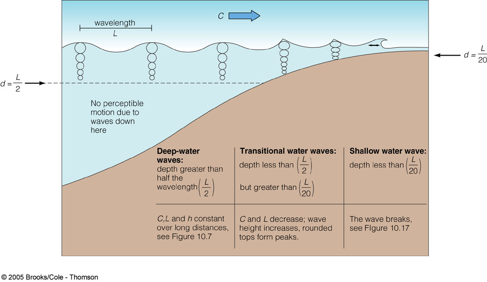
In the deepwater zone, there is no wave interaction with the ocean bottom.
Now that we know how far waves can travel below the surface lets get an understanding of what the continental shelf is and how it will impact the wave energy. A continental shelf is a portion of a continent that is submerged under an area of relatively shallow water. As you go past the shelf, the ocean depth drops off considerably, and around the United States this depth is around 300 feet. If you look back at the equation above, this means that any wave with a period around 11 seconds or greater will interact with the continental shelf around 300 feet. While called a shelf, on the US East Coast, it is a gently sloping area that goes to depths much less than 300 feet, and will interact with most waves that reach the beach.
We mapped out the ocean bottom depths ourselves to get a clearer picture of the bathymetry around the US. Here are the East Coast bathymetry maps:
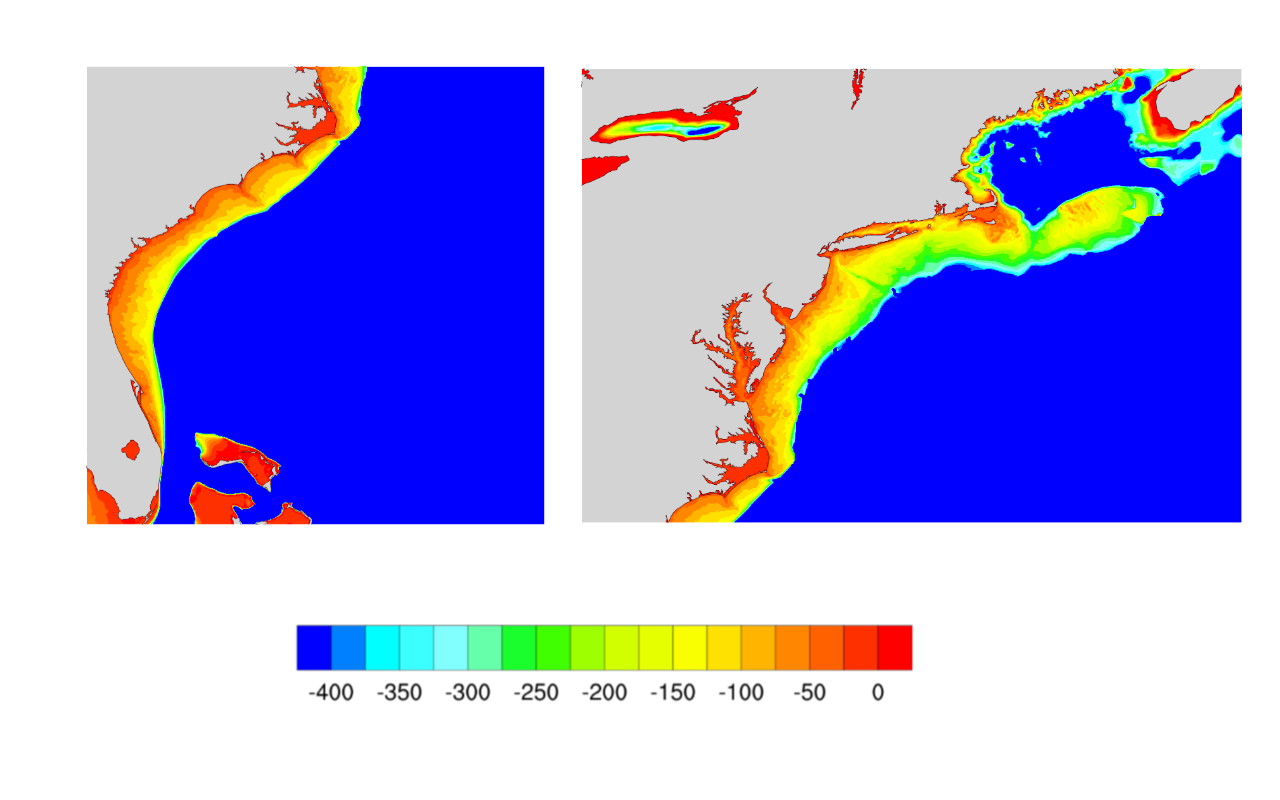
The continental shelf varies in width along the East Coast.
You can clearly see the extent of the shelf along the US East Coast, and how the depths drop off considerably after 300 feet. You will also notice quite a bit of variability in the width of the shelf along the coast. Many areas are around the 50 to 80 mile range, while the Outer Banks is only about 25 miles wide, and the shelf is non-existent in South Florida. You can also notice generally deeper water in the nearshore zones in New England.
We can see there’s a drastic difference to the ocean depths on the west coast in the charts below.
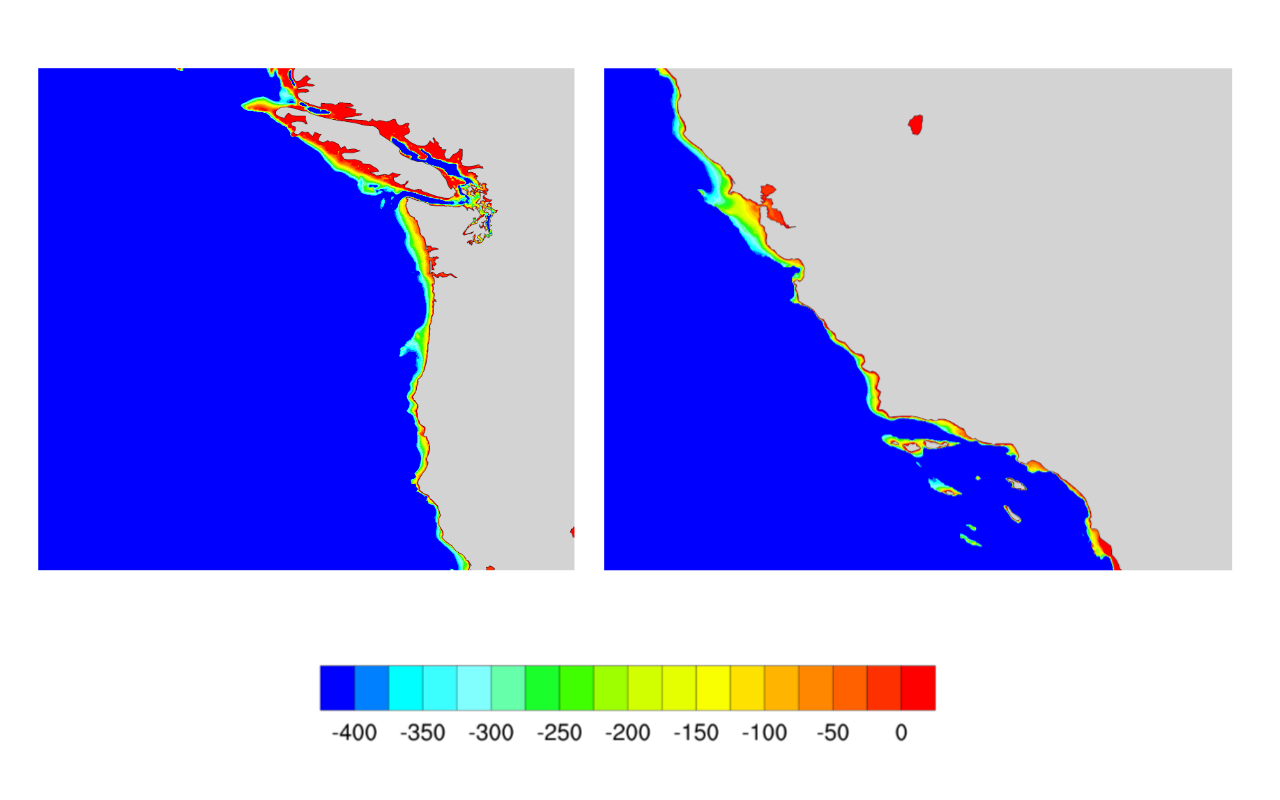
Shallow water areas are very limited along the US West Coast.
While we are only charting depths to 400 feet, the ocean depths drop off to thousands of feet very quickly. You will notice the shallow areas along the West Coast are much shorter in width, generally around 5-10 miles in Southern California, and as much as 25-30 miles near San Francisco.
And, for fun here are the Gulf Coast and Hawaii bathymetry charts. What's particularly notable about Hawaii is the shallow water areas are only about 6 miles or less.
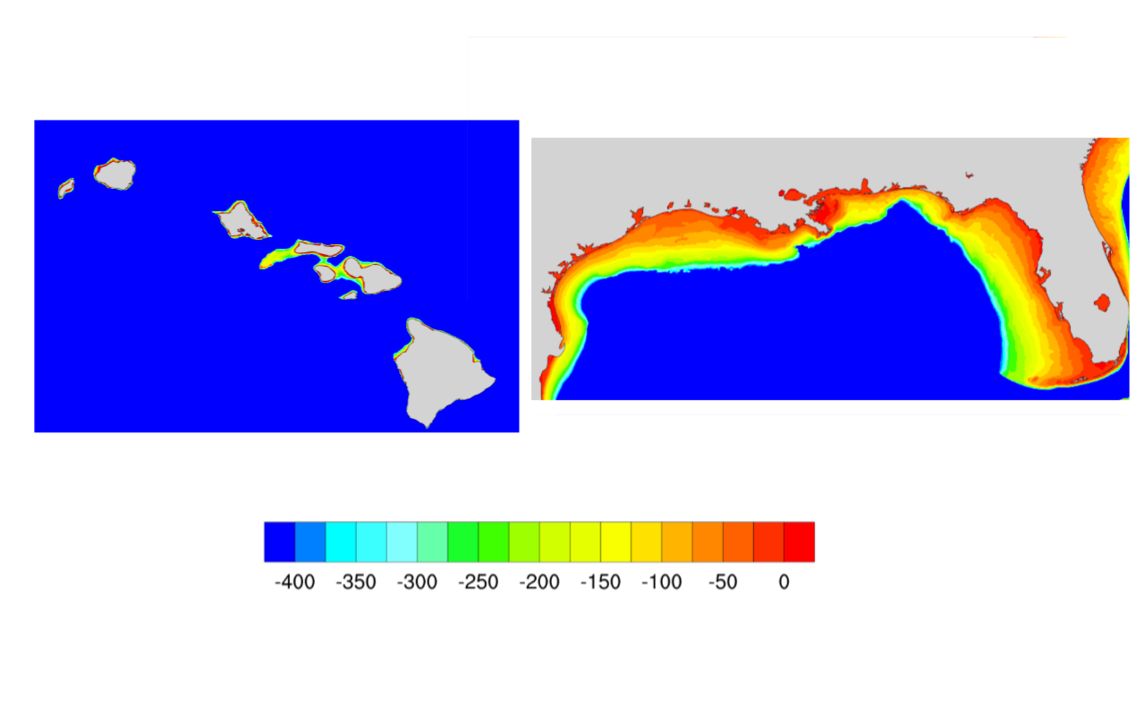
There is a huge contrast in shallow water areas, when comparing the Gulf Coast and Hawaii.
After charting out the ocean depths it's quite easy to see that ocean depths along the East and Gulf coasts are going to impede the wave energy more in comparison to the West Coast or Hawaii. Fortunately, the Surf Captain wave model handles the changes in bathymetry and how the ocean depths influence wave energy. Additionally, Surf Captain uses a nearshore ocean bottom parameter for each region that is used in the forecast to determine the surf heights at each forecast location.