Western Mountain Landscape Photography
A Photo-Essay by Harvey Stearn
There are few things in life that you get to do over. One of them is re-visiting and photographing beautiful scenery decades later.
Before moving to Sedona in 2002, most of my landscapes were of mountain environments which I have loved since early childhood in Colorado Springs. Eventually, I tired of a steady palette of blues, greens, and browns, and sought a different one of brighter, warmer tones. Sedona, in the heart of Red Rock Country, was my solution. The inspiring array of uncommon shapes, bright warm tones and endless texture that characterize Sedona and the adjacent Colorado Plateau, has provided inspiration and impetus. I am not yet tired of this palette, and never will be. But, I did photograph mountains in Colorado and Wyoming as a change of pace.
Lately, I began revisiting specific mountain areas with more purpose and deliberation seeking reconnection and a new inspiration. Only after a half dozen such trips have, I realized that this has been a sub-conscious but a consistent drive to cover old ground armed with improved skill, better technology, and deeper insights. The results are instructive as they demonstrate that my earlier efforts were not limited by the scenery, but instead by my own limited perspectives, planning and work ethic, and by technology as well. During the past six months, I spent time photographing the Canadian Rockies, which I last saw forty years ago; the Wasatch Range in Utah which I visited frequently, but didn’t photograph; and the Eastern Sierras which I last photographed in 1999.
There are three major mountain ranges in the western United States: the Rocky Mountains which run from New Mexico through Colorado and Wyoming and into Canada; the Sierra Nevada Range along the eastern boundary of northern California; and the Cascades that extend from just inside California through Oregon and Washington to the Canadian border.
How They Compare
Each range has a distinctive appearance. But, the Canadian Rockies differ substantially from their U.S. counterparts. The Rockies, Sierras and North Cascades largely consist of granite, and feature sharp jagged peaks, while the Eastern Sierra and South Cascades contain a number of volcanic peaks. In contrast, the Canadian Rockies largely consist of uplifted layered sandstone (as are the mountains of Glacier NP, MT). The American Rockies have 100 peaks over 13,800 feet, with the highest peak reaching 14,440 feet in elevation. The Sierra Nevada and the Cascades each contain 25 peaks over 13,800 feet, with the tallest reaching 14,505 feet and 14,411 respectively. No peak in the Canadian Rockies exceeds 12,989 feet in elevation.
All three U.S. ranges have similar temperatures from June through October. But the Canadian Rockies are about ten degrees colder (Fahrenheit) in mid-winter. Yet this same range warms up faster in April and May and averages the same as the other ranges in Summer and Autumn.
Because the Canadian Rockies are densely forested, with lakes, rivers, and waterfalls in many places, it is easy to assume that they receive more precipitation than the three ranges in the U.S. But, it is largely the opposite. The U.S. Rocky Mountains average over 40 inches of effective precipitation annually, the Cascades over 50 inches a year, while the Sierra Nevada and the Canadian Rockies each average 16 inches annually. However, in the Canadian Rockies, much of the precipitation is retained in large snowfields and glaciers which efficiently maintain the rivers, streams, and lakes, and keep the surrounding forests well-watered.
Though these northern mountains achieve comparable snowfall to what is recorded in the U.S. ranges, the colder Winter weather produces drier lighter snow. In U.S. mountains, one inch of water is the equivalent of 10 to 12 inches of snow. But up north, the ratio is typically one-to-fifteen. Consequently, the Canadian Rockies have lots of snow cover that is super-photogenic. This, and the fact that I hadn’t returned to this area in forty years, made visiting this part of Canada my highest priority in 2018.
The Canadian Rockies
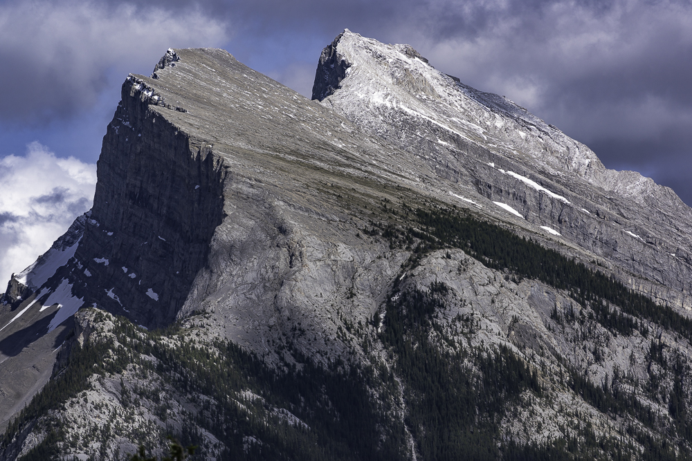
I chose early June to visit because temperatures are comfortable, while the snow cover is still largely intact. The vibrant scenery made me wonder why I had waited so long. Many Canadian lakes have a bright aqua color from sunlight reflected by glacial silt suspended in the water. Also, the layered sandstone of the Canadian Rockies lifted up and tilted over millions of years is picturesque and dramatic as the next image of Banff’s Mount Rundle shows.
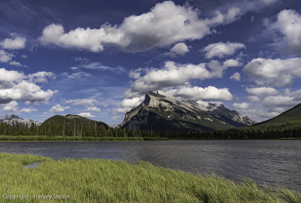
As previously stated, the Canadian Rockies are not as tall as American West mountains. But, they do have a lot of mass as seen in the next image taken at the Vermilion Lakes near Banff.
The city of Banff lies at the south end of Banff NP and is the usual jumping off location for touring the Canadian Rockies with Jasper NP to the north, and Yoho NP to the northeast. Driving through these parks allows many spectacular viewpoints with easy access. Hiking to less well-known spots would have been great. But, even with the limited time, I was able to obtain many satisfying images because there is a captivating perspective in almost every direction.
World-famous Lake Louise is only 57 km (a little more than 37 miles) north of the city of Banff along Canadian Highway 1. One of the classic views appears in the next image.

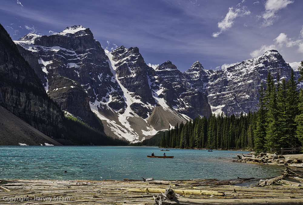
But, only seven miles south of Lake Louise is a smaller lake that I consider to be more representative of the best that the Canadian Rockies has to offer. I photographed Moraine Lake forty years ago, and the thought of recapturing that scene with digital technology was probably my strongest motivation to return. While hardly any noticeable change to the background had occurred during those four decades, the foreground was noticeably different.

My earlier photograph was taken standing on a rock atop the natural earthen dam created by the glacial moraine. From that point, I was able to include the lake shallows and underwater rocks in the foreground. This is no longer possible due to the many stripped fallen trees that piled up on the near shore and covered the shallows. That wasn’t a great loss. But, to reclaim the original perspective I had to walk on those logs while hoping that I didn’t slip and break a leg, or worse, my camera. Tripods were out of the question. Thankfully, my Sony A7riii’s 5-axis image stabilization produced crisp sharp shots even though I struggled to keep stable balance.
What makes this view so exceptional is the unsurpassed color of the water and the procession of at least six mountain peaks of equal height in the background. Eons ago this would have been a single high ridge that was continually eroded from water pouring over the edge. This scene is a wonderful illustration of the geology that formed the Canadian Rockies over the past 50 to 80 million years.
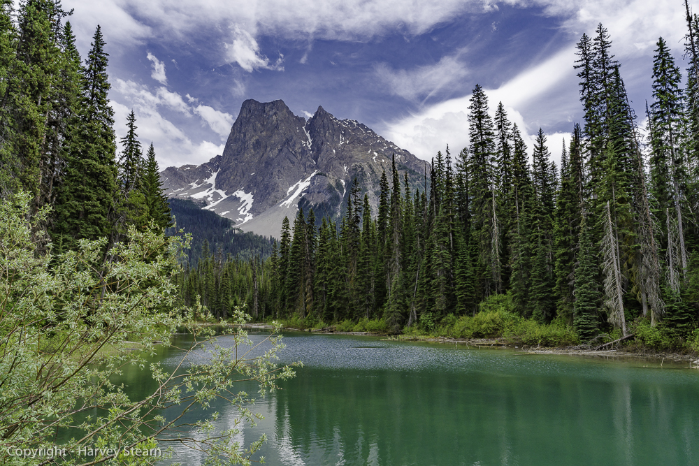
Two miles beyond Lake Louise Highway 1 turns west and enters British Columbia where it skirts the southern edge of Yoho National Park. A short road leading to Emerald Lake is reached less than twenty minutes along that route. Many of Yoho NP’s more dramatic scenes can only be reached with a fair amount of hiking. Emerald Lake is not one of those. As shown in the following image, it has a more serene look. Yet, the power of the nearby peaks is palpable.
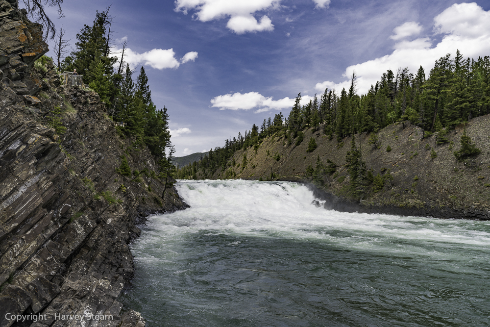
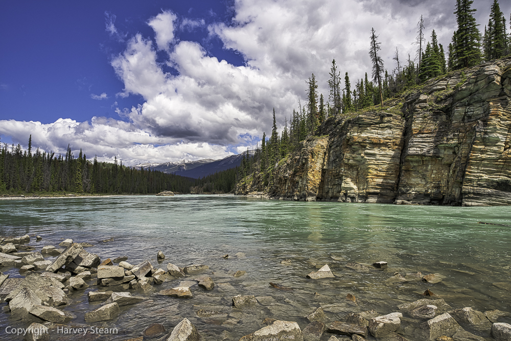
Backtracking along Highway 1 to where it veered west, I turned onto 93 north which becomes the Icefields Parkway, a narrow link between Banff NP to the south and Jasper NP to the north. Along this route, many lakes, rivers, and waterfalls can be seen from the road. Bow Lake lies about 60 miles north of Banff along 93N. Fed by glaciers nestling between Bow Peak and Mount Thompson, Bow Lake feeds Bow River which runs all the way south to Banff where Bow Falls is a popular tourist destination. This stretch beautifully illustrates how melting ice and snow creates lakes that feed far-ranging rivers with waterfalls along the way.

Before leaving Banff NP, another beautiful lake scene with dramatic mountain backdrops lies close to the road. The Waterfowl Lakes display that aqua color due to their glacial origin.

Upon entering Jasper NP, there is a long stretch of glaciated areas that gives the Icefield Parkway its name. Most prominent and accessible of the glaciers in this area is the Athabasca Glacier where snow-cat tours are offered. This glacier feeds two major rivers, the Athabasca River and the Sunwapta River which later merge before flowing north to the Arctic Ocean. The two rivers have spectacular waterfalls not far from the town of Jasper where we would spend four days. These were my highest priorities for re-visiting Jasper National Park. So, I didn’t stop to take photographs until we reached Sunwapta Falls in the late afternoon.
However, the Athabasca Glacier is a major tourist destination. Snow-cat tours are offered there, and the scenery is impressive. Forty years earlier I had hiked along this glacier and fell through a narrow water-filled crevasse covered with thin ice that looked like part of the ice road. My outstretched arms stopped my fall, and I was able to haul myself out soaking wet and covered with glacial “flour”, as was my Leica R3 camera. I was glad that it was in August with the temperature a moderate 70 degrees. In any case, I had no compelling need to stop there again.
I wasn’t sorry. Upper Sunwapta Falls has an unearthly beauty. A round-island splits the river in two forcing it into a nearly perfect circle just before it rejoins and spills down the limestone gorge that it has created over a brief span of two-hundred years.
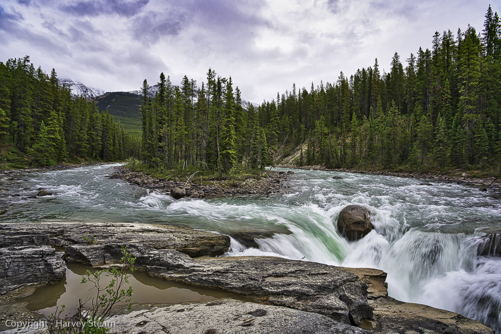
Not long ago it was possible to position a camera to capture both the full circle of the river and almost all of the waterfall. The views are now severely constricted by fencing. To take the above image I had to lean out over the railing and settle for a hand-held exposure. I would have preferred a two-second exposure to smooth out the water. But, setting a tripod was impossible.
Athabasca Falls is a short drive from Jasper. So, I was able to spend a leisurely afternoon there trying different compositions. This scene is highly photogenic from any perspective. I favor the one below as it captures all of the important elements. (I may change my mind next week.)
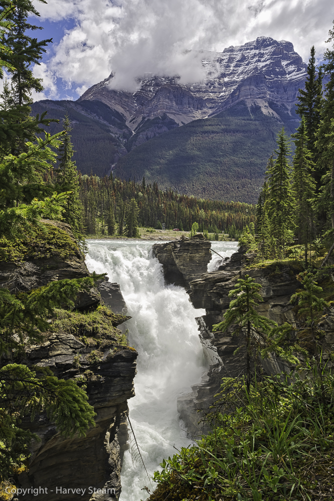
The stairs leading down to the river’s lowest level have a number of scenic viewpoints as the water courses through the narrow gorge. The bottom level is particularly appealing because of the blue-green water that contrasts with the multi-colored layered rock and the deep blue sky.
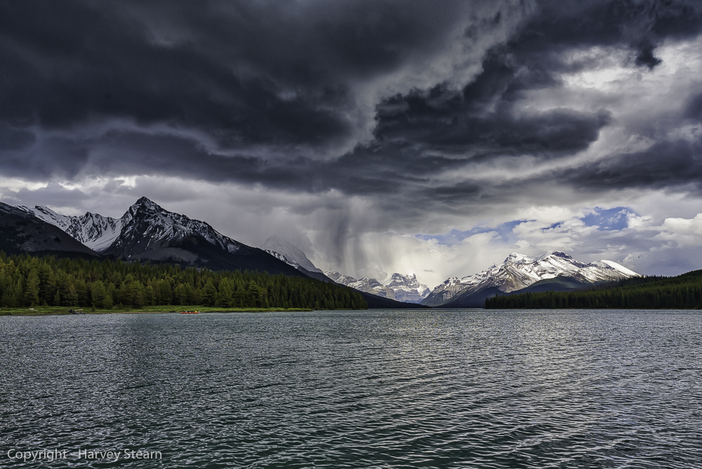
Northeast of Jasper, Maligne Lake Road leads to Medicine Lake and Maligne Lake. Of the two lakes, Maligne is much more photogenic. We took a boat tour of the lake which offered different views and perspectives. On the tour, we were lucky to experience a squall-like rain that provided a wonderful atmosphere and a front row seat to the variable mountain weather.
Revisiting the Canadian Rockies was a wonderful experience. It was a convincing demonstration of how important color accuracy is in separating different tones in the same color family. It wasn’t that I tired of photographing the “more limited” palette of mountain landscapes. It was that color films had limited color accuracy and did not do justice to the rich assortment of blues and greens of mountain environments, particularly in Alberta, Canada.
Of course, mountain scenes come alive with warm colors in early Autumn. I made an additional trip three months later to the Wasatch Range near Park City, Utah, and to the Eastern Sierra in Mono County, CA.
The Wasatch Range
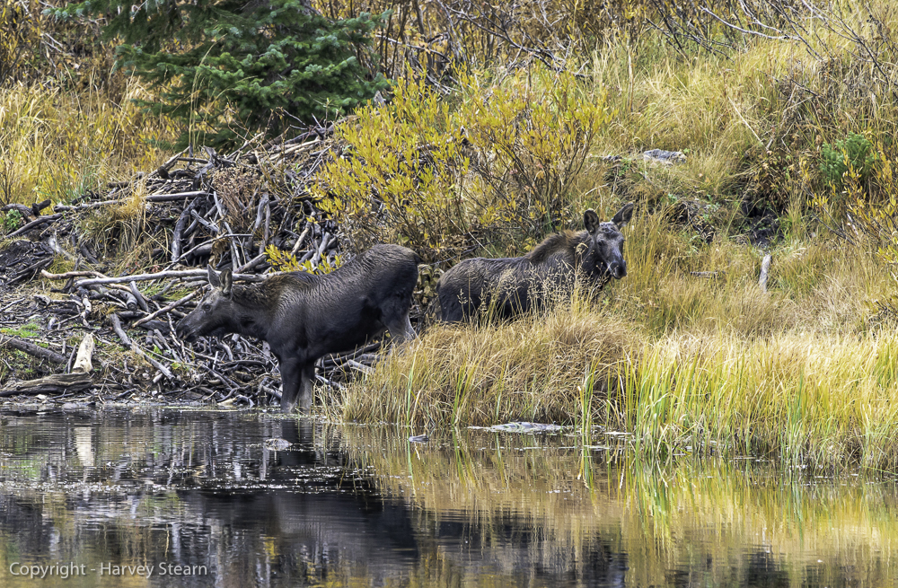
The Wasatch Range is another name for the Western Rockies that are located in Utah. Over the years I skied almost every popular ski resort in this range, but, I never devoted any serious time to photography there. What drew me there this year was not the Fall foliage, although that was a bonus. Instead, I wanted to locate and photograph moose. A trip to the Grand Tetons two years ago didn’t turn up a single one, and I hadn’t seen moose in Yellowstone NP in decades, though I know they are still there. However, I read about Silver Lake which adjoins the Solitude ski resort and learned that moose frequent this lake all year to graze on willow shoots.
On the first day, I saw two moose cows that appeared to be mother and daughter and took a series of shots including the one shown below.
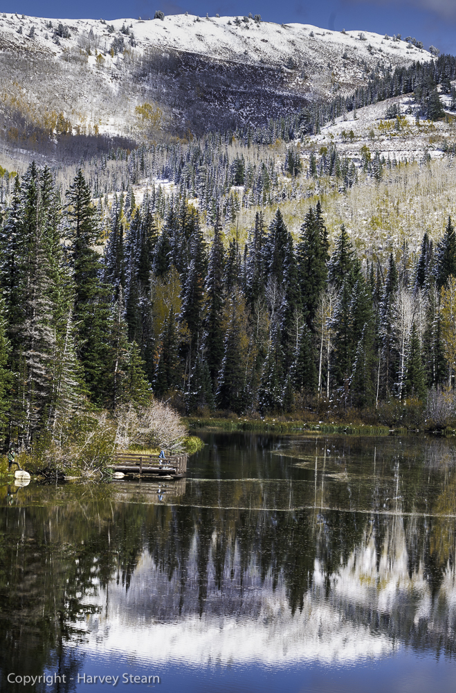
On the second day, I was hoping to come across a bull moose with large antlers. It never happened. However, the lake is lovely in early October, and it snowed the previous night. The next four scenes are a good consolation for defaulting to Plan B.


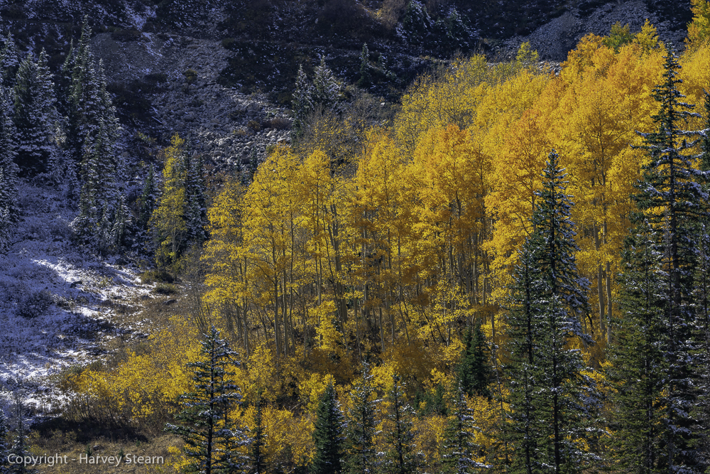
The last image illustrates the not unusual combination of early Autumn peak color and first snowfall. At high elevations, Nature doesn’t follow the calendar, and short-lived brilliant yellows yield to snow by mid-October. On October 10th, ten years earlier I took the following image of a large brilliant cottonwood in Grand Teton NP. The intensifying snowstorm in the nearby mountains would soon cover the base elevations and claim an early victory for Winter.

The Eastern Sierra
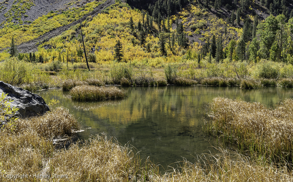
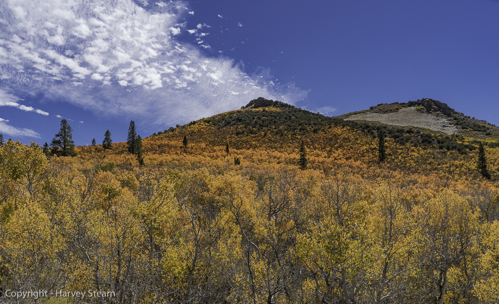
The Mammoth Lakes area had been considerably dryer and warmer when my wife and I hiked there a few days before driving across Nevada to Park City, Utah. Yellow-leafed aspen adjoining the lakes and creeks were almost at the peak, while much orange was visible in pockets at the higher, dryer elevations, as demonstrated by the next three images. The last image was taken at 9500 feet near Bald Mountain south of Mono Lake.

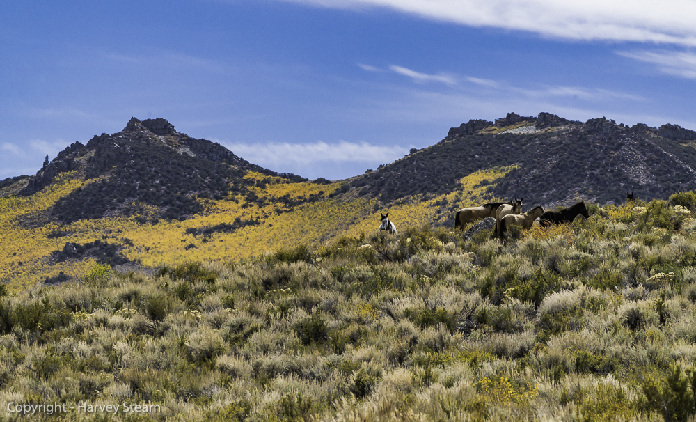
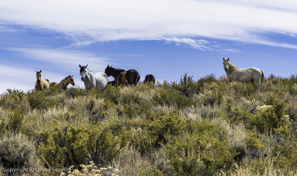
During our first attempt to locate the above aspen grove, we took “the long way around” on an old deeply rutted dirt road. I felt bad for my brother-in-law as three-foot high desert scrub brushed against his brand new Jeep Grand Cherokee. But, we all brightened up when unexpectedly we saw a horse herd grazing on a hill with golden aspen adorning the two background peaks. The horses looked at us as if to say “What are you doing all the way over here?”.
We didn’t know either. But, I got some nice images”
Conclusion
Now it’s apparent that these two mountain trips were the culmination of a personal pilgrimage to finish old business. I had never been satisfied with the silver-based color prints of mountain landscapes that I made between 1960 and 2000. Monochrome prints were okay, but color films rarely reproduced a scene with fidelity. Today, digital technology has changed everything. While selecting images for this article, it struck me how completely today’s best digital cameras capture the full-color gamut found in nature, thereby enabling more accurate colors and better separation of subtle hues, particularly in color ranges that film used to read as a single color. This applies to the warmer tones as well as the cooler ones, and both are important to producing quality mountain landscapes.
Postscript
Earlier, I described differences between the three major western U.S. mountain ranges. I didn’t provide images for the Cascade Range because I didn’t visit them this year. However, to show the sharp craggy appearance of those mountains, the following is an image that I made of Diablo Lake in the North Cascades in May 2017.

Harvey Stearn
July 2019
Sedona, AZ
To see the scope and essence of Harvey Stearn's photographic art please visit www.CameraStops.com. Mr. Stearn began photographing Western landscapes and wildlife at the age of 13, spent 50 years pursuing his passion in the field and in the darkroom before fully converting to digital photography in 2002. He developed color prints as well as monochrome, but switched over to digital capture and editing in 2002. Though he was a top executive for two large scale land development and home building corporations, he always found time for his fine art photography which won many awards. His work was exhibited in art museums in Southern California and Arizona, and was also featured in billboard advertisements and published in magazines. Mr. Stearn served on the California Arts Council for nine years, including two years as Chairman and another two as Vice Chairman. In addition, he was the founding Chairman of the John Wayne Airport Arts Commission in Orange County, California. Mr. Stearn’s work was sold through Arizona galleries for 15 years. In recent years he wrote 33 illustrated articles for PhotoPXL.com and 14 articles for Luminous-Landscape.com. In 2013 he published a book entitled “In Search of the Old West” which has been widely acclaimed. He was a guest lecturer on photography on a cruise ship visiting Chile, Argentina, Uruguay and the Falkland Islands. His work was among the top 100 images printed in NANPA's Showcase publications in 2019 and 2020. Images have been edited and selected for two new books on Landscape photography which will be published in late 2024 and early 2025.