
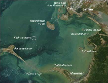
Kachchatheevu which was also caled as vali theevu is small island of about 285 acres and 20 cents comprised. It was located at a distance of 17 km from rameshwaram, tamilnadu in reference to marine distance it was 12 nautical mile from rameshwaram
Before independence it was one of eight island under the control of ramanathapuram sethupathu kings.
In the year 1480 due to the cyclone formed in the bay of bengal rameshwaram & 11 other island are formed in bay of bengal which are
1 rameshwaram
2 kuthukal
3 punavasal
4 muyal theevu
5 pumarison theevu
6 mulai theevu
7 manal theevu
8 Kachcha theevu/vali theevu
9 appa theevu
10 nala thani theevu
11 uppu thani theevu
12 kudisadi theevu
When the zamindar system was introduced in the year 1802 the Kachchatheevu was under the rule of ramanad rulers until 1947 when zamindari system was abolished
During A.D. 1605, the clan of Ramanathapuram Sethupathy King
was established by the Madurai Nayaks, incorporating 69 coastal villages and 7 Islands, of which Katchatheevu Island is one of the
Island.
A copper plate plaque issued by King Koothan Sethupathy who ruled Ramanathapuram during the years 1622- 1635, depicts that the Sea upto Talaimannar belonged to Sethupathy Kings.
In the year 1822 the east india company signed an agreement with ramanad king to use sixty nine village and 7 island(including katchatheevu) for their trading purpose.
In Queen Victoria’s 1858 Proclamation whereby the powers
got transferred to British Rule from East India Company, reference is made that Katchatheevu Island belong to Ramanathapuram Zamin. And also there was not a single word about katcha theevu in the history and ancient books of srilanka.
There is a Registered Document
(Registration No. 510/1880, Book 1, Volume 16) evidencing the fact that on 23.06.1880, eight coastal villages and four Island, including the Katchatheevu Island, belong to the Ramanathapuram Sethupathy’s were given in lease by the District Collector, Madurai jointly to one Abdul Kadar Marakayar and Muthusamy Pillai.
P.P.Peris, who during the years of British Rule in 1936- 40, served as an Assistant Draftsman and later became a Ministerial Secretary after Sri Lanka attained independence, on 08.05.1966, made the following statement, confirming that Katchatheevu Island belonged to Ramanathapuram Kings. He says,
“During the years 1936-40, when I served as Assistant Draftsman in the Land Survey Department, I was directed to survey the district boundaries of Ceylon. Therefore, I perused all records, documents, historical evidences and the Queen Victoria’s proclamation, by which 1 found that Katchatheevu Island belonged to King Sethupathy, Therefore I drew the Northern District of Ceylon delineating Katchatheevu Island.” This statement issued by the Ministerial Secretary on 08.05.1966, was widely reported in the then Daily Mirror published from Sri Lanka and thereafter reported in Indian Express in India.
The earlier map of srilank which was issued by dutch, portuguese and others also doesn’t contain any information about katchatheevu.
When Zamindari Abolition Act came into force, Katchatheevu Island is mentioned as 285 Acres of Government Poromboke land in Ramanathapuram Village.
In all the Indian Land Survey Records issued between the years
1874 and 1956, Katchatheevu Island is depicted as an Indian Territory alone
In the year of 1920 srilankan govt started to say that katchtheevu belongs to them. In 1956 the indian govt started to extent its sea territory from 3 nautical mile to 6 nautical mile and fishery line upto 100 nautical mile the srilankan govt also issued the same type of order due to fear of katchatheevu wheather it will fall in hands of india.
In the year 1973 then indian prime minister indira gandhi travelled to sri lanka and also in the year 1974 sri lankan president sirimavo
bandaranaike came to india. And the agreement was signed between both of them. Katchatheevu was ceded to Sri Lanka without discussing with tamilnadu by Indira Gandhi in the year 1974 december 28.While gifting away the land, Indira Gandhi pointed out that Katchatheevu Island is being ceded not on the basis of records but for other political reasons.
On 31.08.2010, during the discussion in the Lok
Sabha and in earlier discussions in the Rajya Sabha, over Katchatheevu Island, the External Affairs Minister
Mr.S.M. Krishna, asserted the following as his reply which are in
fact false statement:
“Katchatheevu Island belong to Sri Lanka”
“What had been given is given”
“The agreement is solemn”
“It cannot be abrogated”
“It is not possible to provide security to the fishermen who transcend the borders”
“Sri Lanka is our friendly Nation”
THE 1974 INDO SRILANKAN MARITIME BOUNDARY AGREEMENT :
This agreement consists of VIII
Articles. Article I, deals with demarcating the Maritime Boundary
over Palk Straits which comprises the Katchatheevu Island. The principle of Equi-Distance demarcation, normally followed in International treaties was not followed, but instead the demarcation was carried on with a sole object of forgoing Katchatheevu Island to Sri Lanka. As such the Maritime Boundary was drawn above Katchatheevu Island at its West. If the principle of Equi-Distance demarcation was followed, the Maritime Boundary would have
fallen to the East of Katchatheevu Island and the Island would be well within the Indian Maritime Boundary. The United States did not agree to this demarcation, which did not follow the principle of Equi-Distance demarcation. In a nutshell, the principle of Equi-Distance
Demarcation, hundreds of documents from the year 1605 and the
uninterrupted possession over the Island over the past thousand years would establish that the Island of Katchatheevu is part of the Indian territory. The fact that Katchatheevu Island is an Indian territory and had been ceded to Sri Lanka is embedded in Article V of the agreement which deals with the traditional rights of the Fishermen and Pilgrims to go over to the Katchatheevu island.
ARTICLE V :
Subject to the Foregoing Indian fishermen and pilgrims will enjoy
access to visit Katcha Teevu as hitherto and will not be required
by Sri Lanka to obtain travel documents or visa for these purposes. Article VI of the agreement protects the Indian fishing vessels right to venture into and stay in Sri Lankan waters.
ARTICLE VI :
The vessels of India and Sri Lanka will enjoy in each other’s waters such rights as they havetraditionally enjoyed therein.
Article VII deals with effective utilization by both the countries of
Gas and other mineral resources that may be discovered in this Sector. Although, this agreement include ceding Katchatheevu Island to Sri Lanka, in effect this agreement upholds and safeguards the
traditional rights of our fishermen over this sector of the Sea, which
include Island of Katchatheevu and the area surrounding it. The Island of Katchatheevu had remained within the suzerainty of both the Nations. When two sovereign nations exercise their suzerainty over a land or Island, such joint exercise of power is termed a Condominium. International Law permits exercise of such suzerain power by two or more nations over rivers, Seas and the land mass abutting the sea. The exercise of joint suzerain power by England and France since 1934 over Candon and Endenbury is a best example. The 1974 Indo Sri Lankan Pact, is based on this principle of
joint exercise of suzerain power and not a complete ceding of territory as it is being portrayed by Mr.S.M.Krishna.
ARTICLE VIII :
This agreement shall be subject to ratification. It shall enter into force
on the date of exchange of the instruments of the ratification
which will take place as soon as possible.
Article VIII of the agreement stipulates obtaining a ratification,
which could be done by bringing a suitable amendment to the
constitution before enforcing the agreement. No such ratification or
sanction has been obtained. As such this agreement has lost its sanction, has become inoperative and unenforceable. The statement of External Affairs Minister Mr. S.M.Krishna, before Parliament, that this agreement cannot be abandoned it a contemptuous
statement transcending the Constitution, for which act, the
External Affairs Minister, the Prime Minister and his Council of Minister should be held responsible. It is this agreement of the year 1974, which has contributed to killing of
nearly 500 Indian Fishermen, permanently disabled 1000 of them and disappearance at the same number.This agreement which makes a mockery of the Indian Constitution, is according to our External Affairs Minister, Mr.S.M.Krishna, as declared by him before the
parliament “a solemn agreement.”
Mr.S.M.Krishna and his Ministerial counterparts have failed to
remember having taken an oath to protect and preserve the
Constitution. The numerous documents in hand, our
Constitutional provisions, the covenants in the 1974 agreement, supports our view that India has a suzerain power over the Island of
Katchatheevu, and continues to exercise that power and will
continue to exercise the power over Katchatheevu and the surrounding Seas. In effect the Indian fishermen too exercise such rights over the Katchatheevu Island and the surrounding Seas.
Even then the act of foregoing the territory of Island of Katchatheevu by Indira Gandhi is an act contrary to the Constitution of India. The Indian Constitution does not permit nor does it authorize any person to cede the country’s territory to any other Nation.
St Antony shrine
In the year 1905 an rameshwaram fishermen named sinikarupan padayatchi build the St. Antony’s shrine in katchatheevu during every year march 3 the festival will be held in church the prist & pilgrims of both indian and sri lankan attend the festival. For the past few years the sri lankan govt banned the festival
