Traditional geologic maps beautifully illustrate the many different types of rock found on Earth’s surface. Geoscientists can look at a colorful geologic map and immediately spot important pieces of the story of Earth’s geologic history. For instance, in the map below, the red area found in Canada represents bedrock formed in the Late Archean Era somewhere between 4,000 and 2,500 million years ago. But what if you want to convey ideas not only about where different rocks are located on the planet, but also about how these rocks may have formed? And, what if you want to do that for middle and high school students?
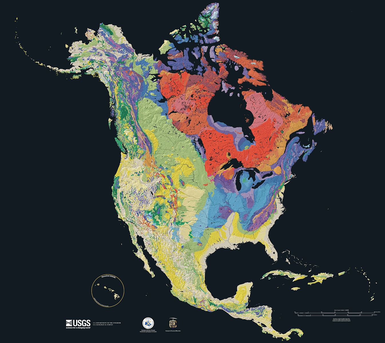
Relief map showing the varying age of bedrock underlying North America. Wikimedia Commons.
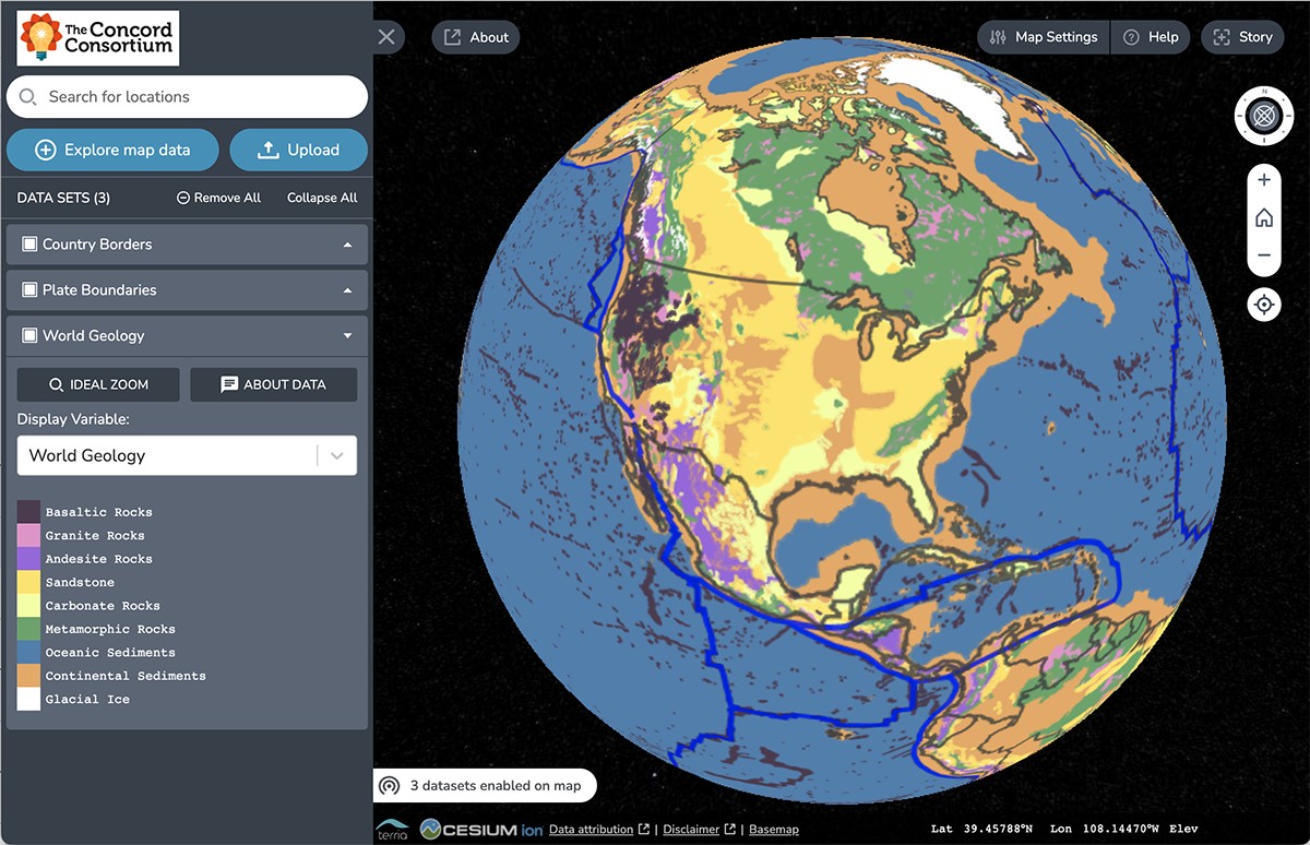
Concord Consortium’s new Earth Rocks Map displays a generalized representation of Earth’s geology, focused primarily on the distribution of the three major rock types (igneous, metamorphic, and sedimentary). What makes this map different is that it strips out information about geologic eras, highlighting the distribution of rocks found on Earth’s surface.
As a 3D model, students can spin the map around and zoom in for a closer look in any area. They can also see a view of all the surface rocks on Earth or turn different rock types on and off to view them one at a time. To view the entire planet at once, students can toggle to a 2D view. (Read about the development of the map here.)
What we hope this map will teach
The TecRocks project has developed a new online module that weaves rock formation and plate tectonics together such that teachers and students can approach these two topics as an integrated system. Our Rocks & Tectonics curriculum module supports students as they build an understanding of rock formation as a process. Different processes create different types of rock depending on the tectonic environment where they are formed, how quickly they cool, how much pressure they are under, and other factors.
Our goal is to help students reason like geoscientists about the interconnectedness of plate tectonics and rock formation. To do this, students need to consider where on Earth rocks are in the process of forming right this very minute and what the rocks formed in the past reveal about their creation in terms of tectonic environment. This new map is one piece of evidence that students use to make these connections.
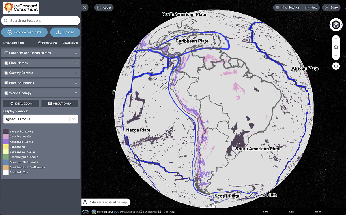
Look at the picture of the Earth Rocks Map below, which shows igneous rocks found at the surface of South America. The plate boundary between the Nazca Plate and the South American Plate reveals clues about the type of rock found there. Through a series of scaffolded investigations, students consider the connection between how the plates are interacting at the boundary, what processes and conditions are occurring there, and why these factors are responsible for the granite and andesite that have formed along the edge of South America.
The Rocks & Tectonics Module
This innovative new map is only one of the interesting tools that we have embedded in our Rocks & Tectonics Module. Students work through a sequence of five activities that focus on particular areas on Earth. For example, case studies, such as the Aleutian Islands and Himalayas, are designed to allow students to explore real-world rock distribution (using the Earth Rocks Map) and seismic data (using Seismic Explorer). While both are convergent boundaries, one is ocean to ocean and the other is continent to continent. These different conditions lead to different processes of rock formation.
Students advance their understanding by using TecRocks Explorer, which includes new features on top of our Tectonic Explorer 3D model. TecRocks Explorer includes added rock layers and conditions for rock formation and transformation to investigate the types of rock that form in different tectonic environments. At the end of each case study, students use what they learned with the embedded tools to answer question prompts that require them to make connections between the tectonic formation and rock genesis.
Over the next two years, we will collect and analyze students’ responses to these questions to answer research questions around their ability to make connections between plate tectonics and rock formation.
Spring 2023 field test
This year, we are testing the new Rocks & Tectonics online module, assessments, and teacher support materials with a small group of teachers. While anyone can use the embedded tools, access to the module is limited to participants in our pilot group. If you would like to join our Spring 2023 field test and are able to teach with the Rocks & Tectonics Module between March and June 2023, please complete an online application. Applications are due on December 16, 2022. This field test is likely to fill up quickly, so apply as soon as possible! If accepted, you will be notified in early January. If you cannot participate in this year’s study but would like to follow the project and learn about additional opportunities, please complete this interest survey. We look forward to working with you!