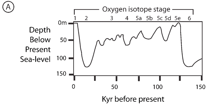
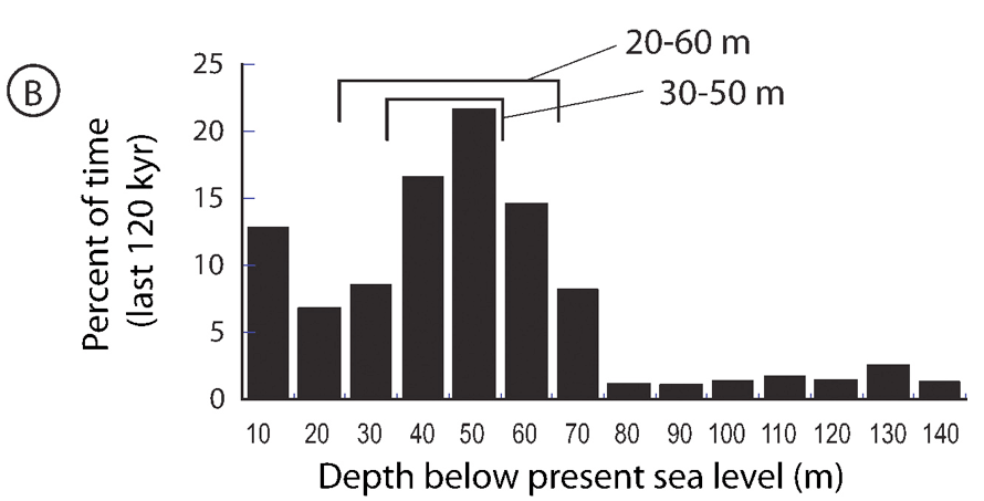
Continental shelf – defined by IHO (2008) as “a zone adjacent to a continent (or around an island) and extending from the low water line to a depth at which there is usually a marked increase of slope towards oceanic depths”.  The low-water mark is taken in this study as the 0 m depth contour.  The shelf break (i.e. the line along which there is marked increase of slope at the seaward margin of a shelf) was digitised manually at a nominal spatial scale of 1:500,000 in ArcGIS based on 10 m, 50 m and 100 m contours, depending on the slope and bathymetric profile of the region.  In most cases 100 m contours were sufficient at the selected scale of 1:500,000 to identify the shelf break.  However, where there was a gradual break in slope over a broad area, more closely spaced contours were used.

The continental shelf is the shallow seafloor, generally less than 200m in water depth, which surrounds continents and islands.  Geologically, the shelf is similar to the rest of the continent in that its foundation is comprised of granitic crustal material.  Strictly speaking, the shelf extends from the shoreface zone to an offshore location where the seaward dipping, low gradient (about 0.1°) shelf gives way with a rapid change in slope known as the shelf break.  Continental shelves are most commonly classified on the basis of geomorphology (eg. rimmed carbonate shelves exhibit distinctive features that distinguish them from glacially-incised shelves) or tidal range (tide-dominated shelves covered with elongate tidal sand banks, for example).

In this study we classified continental shelves on their vertical relief (roughness) by assessing the vertical relief within an area of ~80 km2 to define continental shelf areas of low (< 10m), medium (10-50 m) and high (>50 m) vertical relief.

Shelf classification categories (from Harris et al., 2014).  The percentage areas first line refers to percentage of ocean region area and the second line refers to percentage of shelf area within a region. The three subdivisions of continental shelf based on roughness illustrates that medium (10-50 m) relief shelf covers the greatest area (14,447,690 km2), followed by low (< 10m) relief shelf (9,799,880 km2) and the least area is classified as high (>50 m) relief shelf (7,995,040 km2).  High relief shelf area is most common in the higher latitudes, which is probably explained by glacial processes.  However, shelves bordering the two polar seas are direct opposites in terms of their percentage cover of low, medium and high relief shelf.  Whilst the Antarctic (Southern Ocean) shelf has the highest fraction of shelf area in the high-relief category at 69.3%, the Arctic shelf has a greater fraction of low relief shelf (45.1%) than any other ocean region.

OceanShelf Area km2Shelf Area%Low (< 10m) Relief Area km2Low Relief Area%Medium (10-50 m) Relief Area km2Medium Relief Area %High (>50 m) Relief Area km2High Relief Area %
Arctic Ocean (Shelf)6,727,44051.83,033,17023.3 (45.1)2,592,83020.0 (38.5)1,101,4508.48 (16.4)
Indian Ocean (Shelf)4,047,5705.681,154,3101.62 (28.5)2,065,8802.90 (51.0)827,4501.16 (20.4)
Mediterranean and Black Sea (Shelf)709,99023.5136,5504.52 (19.2)321,86010.6 (45.3)251,5808.32 (35.4)
North Atlantic Ocean (Shelf)7,313,79016.31,839,0104.11 (25.1)3,771,7208.43 (51.6)1,703,0603.80 (23.3)
North Pacific Ocean (Shelf)6,144,8107.502,141,5702.61 (34.9)2,815,7003.44 (45.81,187,5601.45 (19.3)
South Atlantic Ocean (Shelf)2,036,1405.04436,3101.08 (21.4)1,298,4803.22 (63.8)301,3500.747 (14.8)
South Pacific Ocean (Shelf)2,547,4502.92969,3501.11 (38.1)836,1600.958 (32.8)741,8600.850 (29.1)
Southern Ocean (Shelf)2,715,36013.489,6100.441 (3.30)745,0603.66 (27.4)1,880,7309.25 (69.3)
All Oceans (All shelf)32,242,5408.919,799,8802.71 (30.4)14,447,6903.99 (44.8)7,995,0402.21 (24.8)

Factors controlling shelf geomorphology

As the name implies, continental shelves are a part of the continent; they are underlain by continental crust and thick sedimentary deposits of continental origin. In a global context, the depth of the shelf break (20 to 550m water depth; commonly defined as 200m) and the width of the shelf (2 to 450km) exhibit a wide variability.  Continental shelves cover an area of about 27 million km2, equal to about 7% of the surface area of the oceans. The continental shelf extends from beach (foreshore) environments, across the shoreface to an offshore location where the seaward dipping, low gradient (~1:2,000) shelf gives way at the shelf break to a steeper gradient continental slope.  The shelf is thus bounded, inclusively, by the shoreface and the shelf break. The shoreface is generally a zone of active sediment reworking, delimited at its offshore margin by the so-called fairweather wave base, which is the downward limit of effective wave-induced sand movement during normal sea conditions.  In a shore-normal transect, the shoreface is bathymetrically a concave up feature.

The major controls on shelf morphology include tectonic setting, sea level history, glaciation, rate and type of sediment supply and energy available to erode, rework and disperse sediment.  Different controls may overlap, form a matrix of possible combinations of shelf type.  The benthic communities and assemblages characteristic of different geomorphic effects are well known in some cases, whereas for other shelf types very little is known about the benthic ecology.

Tectonic setting

The tectonic setting of continental margins varies depending on the type of plate boundary: passive versus active.  Along passive plate boundaries, sediment supply from the hinterland is generally low and the shelf sediments are commonly characterised more by biogenic sediments than by terrigenous (land-derived) sediments supplied by rivers.  The shelf width ranges from broad to narrow, depending on the age and configuration of the plate boundaries.  The broadest continental shelves are found on passive, trailing continental margins associated with wave erosion and limited sediment input.  Good examples include the west European and eastern North American shelf seas.  Broad shelves are also found behind active margins, away from the zone of tectonic uplift where slow rates of subsidence occur (foreland basin); the continental shelf of northern Australia is of this type.

Shelf classification categories (from Harris et al., 2014).  The percentage areas first line refers to percentage of ocean region area and the second line refers to percentage of shelf area within a region. The three subdivisions of continental shelf based on roughness illustrates that medium (10-50 m) relief shelf covers the greatest area (14,447,690 km2), followed by low (< 10m) relief shelf (9,799,880 km2) and the least area is classified as high (>50 m) relief shelf (7,995,040 km2).  High relief shelf area is most common in the higher latitudes, which is probably explained by glacial processes.  However, shelves bordering the two polar seas are direct opposites in terms of their percentage cover of low, medium and high relief shelf.  Whilst the Antarctic (Southern Ocean) shelf has the highest fraction of shelf area in the high-relief category at 69.3%, the Arctic shelf has a greater fraction of low relief shelf (45.1%) than any other ocean region.

SHELFActive MarginsPassive MarginsAll Margins
OceanMean (km)Max (km)Mean (km)Max (km)Mean (km)Max (km)
Arctic Ocean00104.1 ± 1.7389104 ± 1.72389
Indian Ocean19 ± 0.6117547.6 ± 0.823837 ± 0.58238
Mediterranean and Black Seas11 ± 0.297938.7 ± 1.516617 ± 0.44166
North Atlantic Ocean28 ± 1.08259115.7 ± 1.643485 ± 1.14434
North Pacific Ocean39 ± 0.7141234.9 ± 1.211439 ± 0.68412
South Atlantic Ocean24 ± 2.655123.0 ± 2.5453104 ± 2.4453
South Pacific Ocean21 ± 0.413649.6 ± 1.920724 ± 0.42207
Southern Ocean214 ± 2.8635796.1 ± 2.0778110 ± 1.92778
All Oceans31 ± 0.441288.2 ± 0.777857 ± 0.41778

On tectonically active continental margins associated with subduction zones, shelf widths are commonly less than 20 km.  The narrow width is caused by the tectonic uplift of mountains along the continental margin, which is associated with a narrow coastal plain and continental shelf.  High sediment yields from adjacent mountains result in shelf sediment being mainly terrigenous (rather than biogenic) in origin.  The west coasts of North and South America are examples of this type of margin.

Map showing the locations of active and passive continental margins and the eight ocean regions described in the text.

Effects of sea level change

All plants and animals living today on the continental shelf are colonists that arrived in the last 10,000 years or less.  During the last ice age, which reached its peak at around 18,000 years ago, global sea level was around 120 m below its present position and most of the world’s shelf area was exposed[1].  Terrestrial plants and animals lived on the continental shelf during the Pleistocene[2] ice ages. The shelf has only recently become a marine environment and in some locations the process of colonisation may still be underway.  Interglacial, high sea level conditions such as exist at present, have occurred for only around 12% of the time during the past 150,000 years.

Changes in sea level have profoundly affected the biodiversity and distribution of marine life on continental shelves.  At the peak of the last ice age the area of shallow continental shelf, where benthic photosynthesis is possible, was approximately 80% less than its present extent (Tassinari et al., 1996). Shallow coral reef habitat was reduced by a similar proportion during the ice age (Veron, 2008).

Sea level rise and fall relative to a given coastal province is the function of three different, though often contemporaneous, processes: (i) the melting

and/or formation of polar ice caps causing eustatic sea level changes; (ii) the loading of the earth’s lithosphere with sediment, water or ice resulting in deformation causing isostatic changes; and (iii) the collision or rifting apart of continental plates or the subduction of oceanic crust beneath continental margins causing vertical movements, termed tectonic sea level changes.  The relative importance of each process varies from one shelf to another (or even across a shelf, from coastline to shelf break) and hence there is no single, globally-applicable, sea level curve.

During past lower sea level stands, coastlines would have occupied positions on what is now the outer continental shelf or upper slope.  Therefore, the morphology, sedimentology and benthic habitats of the present outer shelf and upper slope are partially the product of past, low sea level terrestrial and coastal sedimentary processes and partially the product of modern sea level shelf processes.

[1] The continental shelf of Antarctica is one important exception; it has an average depth of around 350 m and therefore it was not subareally exposed during the last ice age.
[2] The Pleistocene epoch extends from about 2 million years ago up to the beginning of the Holocene, 10,000 years ago.

Global eustatic sea level curve for the last 150,000 years (from Chappell and Shackleton, 1986).  Oxygen isotope stages are after Martinson et al. (1987). (B) Histogram showing percentage of time that sea level has been within 10-m depth bands (i.e., 0–10 m, 10–20 m, etc.) over that past 120,000 years (isotope stages 1 to 5d, inclusive, equal to one full glacial cycle), based on the curve shown above. The graphs show that sea level was within the 30–50-m depth range for approximately 38% of the time (46,400 years) over the past 120,000 years. For comparison, sea level has been within the 20–60-m depth range for approximately 60% of the time (74,500 years) and in the 0–10-m range for only 12.8% of the time (15,500 years).

Effects of glaciation

Glaciation of the continents during the last ice age extended out across what are now the continental shelves of Antarctica, western and northeastern North America, western Europe, Greenland, Iceland, South America and New Zealand. U-shaped glacial valleys (fjords) in places extend the full width of the shelf, with over-deepened troughs close to the coast rising upwards near the outer shelf.  The valleys were flooded during the rising sea level and glacial retreat from the shelf and are now marine basins that are perched on the shelf; the Alaskan, Antarctic and Norwegian shelves are examples of this type of morphology (Sharma, 1979; Anderson, 1999).  The unique habitat provided by such basins is characterised by rapid, fine grained sedimentation, restricted water circulation and a tendency towards anoxic bottom water and sediment conditions (Hambrey, 1994).

A distinguishing process of polar shelves is the effects of ice-turbation on benthos.  Icebergs calved from Arctic and Antarctic glaciers run aground on the seafloor to depths of up to 350 m, killing the benthos and ploughing the seabed sediments (Woodworth-Lynus et al., 1991).  Where sea ice intersects the coastline, it causes disturbance in the intertidal zone, with a distinct depth zonation (Gutt, 2001).  However, in their comparative analysis, Brey and Gerdes (1997) reported that there was no significant difference of macro-benthic biomass in the 0-10 m depth range between Antarctic versus non-polar regions.  However, Antarctic macro-benthic biomass between 10 and 1,000 m water depth is significantly greater than the biomass of non-polar continental margins (Brey and Gerdes, 1997).

Biotopes were mapped by Beaman and Harris (2005) on the George Vth Land glacially-incised shelf.  Communities comprising sponges, echinoderms and molluscs occur in association with different depths, currents and water masses.  Below the effects of iceberg scour (depths >500 m) in the basin, the broad-scale distribution of macrofauna is largely determined by substrate type, specifically the mud content of bottom sediments.  High salinity shelf water formed on the shelf in winter by brine rejection during sea-ice formation, flows across the shelf and cascades down the George Vth slope contributing to the production of Antarctic Bottom water.  In 2008, cold-water corals were observed in underwater video at the site of the bottom water cascade, presumably benefiting from the suspended food particles carried by the flow.

Carey (1991) reviewed the ecology of the Canadian Arctic shelf and noted the effects of sea level change on limiting faunal diversity.  The polychaete worm fauna in the western Beaufort Sea (to a depth of 300 m) contains very few endemics, whereas the deeper bathyal fauna has more endemic species and is related to the Atlantic fauna, suggesting that this fauna is older and has been isolated from the Pacific fauna by the shallow Bering Strait.  The Canadian bivalve fauna is arctic-circumpolar with few Atlantic or Pacific species. In a global analysis, Gray (2001) reported that the pole to equator increase in benthic biodiversity found for the Arctic is not found in the Southern Ocean which Gray (2001) attributes to the greater (geologic) age of the Southern Ocean fauna compared with the Arctic.

Bathymetry (contours) and biotopes (colours) of the George V Land shelf, Antarctica, after Beaman and Harris (2005). Profiles shown in Sections 1 and 2 show the occurrence of different biotopes in relation to depth, currents (ACC = Antarctic Coastal Current) and water masses (WW = Winter Water; HSSW = High Salinity Shelf Water; MCDW = Modified Circumpolar Deep Water; AABW = Antarctic Bottom Water).  The coral community at 800 m depth in Section 2 is based on Australian Antarctic Division unpublished data.

Effects of carbonate deposition

Ginsburg and James (1974) suggested that shelves can be grouped into two broad categories: (i) open shelves; and (ii) rimmed shelves where a shelf-edge barrier reef has accreted over geologic time.  The barrier reef (rim) acts to restrict the propagation of surface waves and water circulation.  In contrast, open shelves have the profile of a seawards-dipping ramp, with a relatively smooth profile.

The initiation and growth of coral reefs forming the major barrier reef systems on earth occurs over several sea level cycles, with new coral limestone being deposited during each interglacial period.   The carbonate rim is a high-energy, barrier reef environment where coral reefs flourish and for which there is a vast scientific literature.

Three-dimensional colour bathymetry image showing an example of the northern Great Barrier Reef “rimmed” continental shelf.  Note how the shelf morphology contrasts with the non-rimmed Gulf of Papua.  Elongate coral reefs and incised valleys adjacent to Torres Strait are the product of strong tidal flows.  Ashmore reef is a coral atoll.  Colours are related to depth and elevation (red = mountains; yellow = low-lying coastal plains; green-aqua = shelf depths 5-50 m; light blue = deep shelf depths 50-200 m; and dark blue = continental slope depths 200-2000 m).

Effects of waves, tides and currents

A widely known classification scheme of different types of continental shelf is that which emphasises the role of different shelf currents (Swift, 1972). Thus, continental shelves are dominated by either: (1) storm currents (80% of the worlds shelves); (2) tidal currents (17%); or (3) intruding ocean currents (3%).  The dominant current regime not only determines the distribution of shelf habitats and sediments, but also the frequency and intensity of currents controls the dispersal of larvae and food supply to benthic communities. In addition to storm events, tides and ocean currents, it should be noted that strong currents on the shelf are also the product of other oceanic processes such as density-driven currents and internal waves.  However, Swift’s (1972) scheme focuses on the more commonly found current regimes and their associated shelf habitats.

Harris and Coleman (1998) used global (modelled) estimates of significant wave height and period to predict that 0.1 mm diameter quartz sand had the potential to be mobilised on at least one occasion between July 1992 and July 1995 over 41.6% of the earth’s continental shelves. The North Atlantic region has the most energetic global wave climate, strong enough to mobilise 0.1 mm diameter quartz sand to water depths of up to 234 m at least once over a 3-year period.

As the name suggests, storm-dominated shelves are those where storm waves and currents are the agents controlling sediment movement and habitat type. On any shelf, the energy expended and the amount of sediment transported during one storm event may equal many years of non-storm background processes.  Even on highly dynamic, tidally influenced shelves, the effect of a storm is to initiate sediment movement at even greater water depths and at greater rates in shallower depths than are experienced under normal conditions (Morton, 1988).  Storm dominated shelves may experience less than one or as many as four or five storm events per year which cause sediment transporting flows (Swift et al., 1981).

Swift (1976) suggested that storm-dominated continental shelves can be divided into three parts; (i) the inner shelf characterised by storm generated flows and complex bedform assemblages; (ii) the mid shelf characterised by geostrophic flows and surficial sediments that are either relict or affected by mud accumulation; and (iii) the outer shelf characterised by frontal processes which develop at the interface between shelf and open ocean water masses.

The highest level of energy expended in erosion and transport is on the shoreface and this decreases offshore to some water depth known as the storm wave base.  Since smaller storms will affect sediment movement only in shallow water, the frequency and intensity of storm impact will decrease offshore, as will the frequency of cross-bedded deposits.  In contrast, the longer time between storms on the outer shelf implies that outer shelf deposits will be more thoroughly bioturbated than inner shelf deposits.  Such a pattern is suggestive of proximality trends as described by Aigner (1985).

On tropical shelves, storms occur as extreme events known as typhoons, hurricanes or cyclones.  The currents produced by a storm are the combination of geostrophic and wave-induced currents and cause high degrees of seabed erosion.  In the Gulf of Mexico, extreme seabed erosion of 1-2m has been reported from scour observed around pipelines (Morton, 1988) but erosion to a depth of a few 10’s of centimetres is probably a more typical response, and this is likely to be highly variable from place to place on the shelf. Tropical storms are associated with atmospheric, low-pressure systems which attain mean wind speeds of >63 km/hr and exhibit clear spatial patterns in return frequency.  The frequency of tropical cyclone occurrence in Australia, for example, attains 25 cyclones/decade on the continent’s northwest shelf and up to 15 cyclones/decade in the Great Barrier Reef province.

References

Aigner, T., 1985. Storm depositional systems. Springer-Verlag, Berlin.

Anderson, J.B., 1999. Antarctic Marine Geology. Cambridge Univ ersity Press, Cambridge, UK.

Beaman, R.J., Harris, P.T., 2005. Bioregionalization of the George V Shelf, East Antarctica. Continental Shelf Research 25, 1657-1691.

Brey, T., Gerdes, D., 1997. Is Antarctic benthic biomass really higher than elsewhere? Antarctic Science 9, 266-267.

Carey, A.G., 1991. Ecology of North American Arctic Continental Shelf Benthos: A Review Continental Shelf Research 11, 865-883.

Chappell, J., Shackleton, N.J., 1986. Oxygen isotopes and sea level. Nature 324, 137-140.

Ginsburg, R.N., James, N.P., 1974. Holocene carbonate sediments of continental shelves, in: Burk, C.A., Drake, C.L. (Eds.), The Geology of Continental Margins. Springer-Verlag, Berlin, pp. 137-155.

Gray, J., 2001. Antarctic marine benthic biodiversity in a world-wide latitudinal context. Polar Biology 24, 633-641.

Gutt, J., 2001. On the direct impact of ice on marine benthic communities, a review. Polar Biology 24, 553-564.

Hambrey, M.J., 1994. Glacial Environments. UCL Press, London.

Harris, P.T., Coleman, R., 1998. Estimating global shelf sediment mobility due to swell waves. Marine Geology 150, 171-177.

Harris, P.T., MacMillan-Lawler, M., Rupp, J., Baker, E.K., 2014. Geomorphology of the oceans. Marine Geology 352, 4-24.

IHO, 2008. Standardization of Undersea Feature Names: Guidelines Proposal form Terminology, 4th ed. International Hydrographic Organisation and Intergovernmental Oceanographic Commission, Monaco, p. 32.

Morton, R.A., 1988. Nearshore responses to great storms, in: Clifton, H.E. (Ed.), Sedimentologic consequences of convulsive geologic events. Geological Society of America, pp. 1-22.

Sharma, G.D., 1979. Marine geology of the Alaskan shelf, incorporating meteorological, hydrographic, sedimentological and geochemical data. Springer-Verlag.

Swift, D.J.P., 1972. Implications of sediment dispersal from bottom current measurements; some specific problems in understanding bottom sediment distribution and dispersal on the continental shelf: a discussion of two papers.  , in: Swift, D.J.P., Duane, D.B., Pilkey, O.H. (Eds.), Shelf sediment transport: process and pattern. Dowden, Hutchinson and Ross, Stroudsburg, Pennsylvania, pp. 363-371.

Swift, D.J.P., 1976. Continental shelf sedimentation, in: Stanely, D.J., Swift, D.J.P. (Eds.), Marine Sediment Transport and Environmental Management. John Wiley & Sons, New York, pp. 311-350.

Swift, D.J.P., Young, R.A., Clark, T.L., Vincent, C.E., Niedoroda, A., Lesht, B., 1981. Sediment transport in the Middle Atlantic Bight of North America: synopsis of recent observations, in: Nio, S.D., Shuttenhelm, R.T.E., van Weering, T.C.E. (Eds.), Holocene marine sedimentation in the North Sea Basin. International Association of Sedimentologists, pp. 361-383.

Tassinari, G., Campara, D.J.H.C., Kothiyal, M.P., Tiziani, H.J., Schaaf, A., 1996. Sea level changes, continental shelf morphology, and global paleoecological constraints in the shallow benthic realm: a theoretical approach Palaeogeography, Palaeoclimatology, Palaeoecology 121, 259-271.

Veron, J.E.N., 2008. A reef in time: the Great Barrier Reef from beginning to end. Havard University Press, Cambridge, Mass.

Woodworth-Lynas, C.M.T., Josenhans, H.W., Barrie, J.V., Lewis, C.F.M., Parrott, D.R., 1991. The physical processes of seabed disturbance during iceberg grounding and scouring. Continental Shelf Research 11, 939-961.